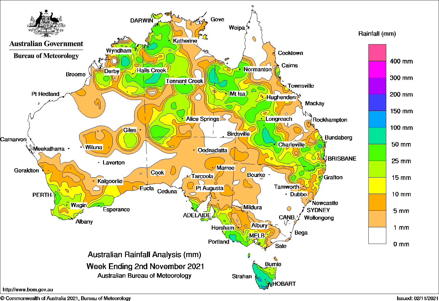
A COMPLEX low pressure system and cold fronts brought thunderstorms to south-east Australia, and thunderstorms generated moderate falls across northern, central and eastern regions.
Past seven days: At the start of the week, a trough and a low pressure system crossed southern Western Australia, and brought light to moderate falls to the south-west of that state. A cold front and pre-frontal trough moved through South Australia and the far south-east of Australia, and produced light falls over southern Western Australia, and parts of the agricultural districts of South Australia, with moderate falls in the coastal areas. A surface trough extended from the Kimberley, across the Top End to south-east Queensland. Thunderstorms developed near the surface trough over the Kimberley, the north-west Top End in the Northern Territory, and in spots from north-west to south-east Queensland.
The low in the west moved to South Australia and deepened over south-east South Australia early on the 28th, with the associated frontal system extending south over Tasmania. Moderate to locally heavy falls were recorded in far south-east South Australia, south-west Victoria (including more than 50 mm at both Coleraine and Portland and Tasmania, including 59.6 mm at Cape Grim, a new October daily rainfall record for that site.
Around mid-week, the deep low moved quickly south-east across southern Victoria, and north-east Tasmania, and moved into the Tasman Sea, with the associated cold front moving through parts of eastern Australia.
In the north, a broad area of low pressure extended into the Northern Territory and across north-west to south-east Queensland, with the associated cloudband linking to the cold front tracking across the south-east of that state, and north-east New South Wales. Thunderstorms and showers produced moderate falls in the Kimberley, the central NT and the Top End, western and southern Queensland, and north-east New South Wales.
At the end of the week, surface troughs stretched across the north, and from the Gulf Country through the central west to south-east Queensland. Extensive thunderstorms and showers brought widespread moderate falls to the Kimberley and Interior districts in Western Australia, most of the Northern Territory, and in the Gulf Country, north tropical coast, and central west of Queensland.
Rainfall totals in excess of 50 mm were recorded in parts of the Kimberley in Western Australia, spots in the Northern Territory and western Queensland, south-west Victoria and most of Tasmania except the north-east. The highest rainfall for the week was 97 mm at Mount Read in western Tasmania, and at Point Stuart in Top End of the Northern Territory.
Rainfall totals of 10 mm to 50 mm were recorded in south-west, northern and the Southern Interior District of Western Australia, most of the Northern Territory, north-western and southern South Australia, the southern half and the alpine regions of Victoria, Tasmania, north-eastern New South Wales, and northern, western and southern Queensland.
Highest weekly totals
New South Wales and Australian Capital Territory
87 mm Coffs Harbour Airport
78 mm Minnie Water (Pump Shed)
75 mm Wooli Beach
Victoria
62 mm Coleraine Hospital
59 mm Portland
58 mm Portland (Cashmore Airport)Casterton
Queensland
76 mm Charleville Aero
70 mm Warilda
68 mm Barcaldine Post Office
Western Australia
77 mm Marion DownsSiddins Creek
61 mm Mount AmhurstArgyle Aerodrome
South Australia
44 mm Nangwarry Forestry SA Depot
42 mm Padthaway South
39 mm Mount Gambier Aero
Tasmania
97 mm Mount Read
85 mm Woodbridge
81 mm Butlers Gorge
Northern Territory
97 mm Point Stuart
85 mm Tindal RAAF
84 mm Daly Waters Airstrip
HAVE YOUR SAY