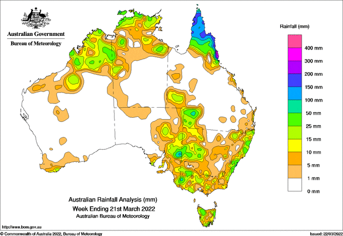
WEEKLY rainfall totals over 150 mm were recorded on Queensland’s north tropical coast and across the Cape York Peninsula, mainly from a south-easterly wind surge early and in the middle of the week.
Localised weekly totals of 25-100 mm were recorded from storms in the Kimberley region of Western Australia and the Top End of the Northern Territory, along the New South Wales coast, in eastern South Australia and adjoining regions of western New South Wales and Victoria.
Weekly highlights
Weekly rainfall totals over 150 mm were recorded on Queensland’s North Tropical Coast and across the Cape York Peninsula, mainly from a south-easterly wind surge early and the middle of the week. The highest weekly total was 469.0 mm at Mt Sophia on the coast south of Cairns in Queensland.
Localised weekly totals of 25–100 mm were recorded from storms in the Kimberley region of Western Australia and the Top End of the Northern Territory, along the New South Wales coast, in eastern South Australia and adjoining regions of western New South Wales and Victoria.
Areas of northern Tasmania received weekly totals of 25–50 mm from the passage of cold fronts in the middle of the week.
Light falls, with weekly totals less than 10 mm, were recorded in central New South Wales, much of Victoria, and along the south coast of Western Australia from a cold front.
Flood Warnings remain current across southern parts of Queensland and northern and inland parts of New South Wales, with flooding ongoing for the Balonne River in southern Queensland.
HAVE YOUR SAY