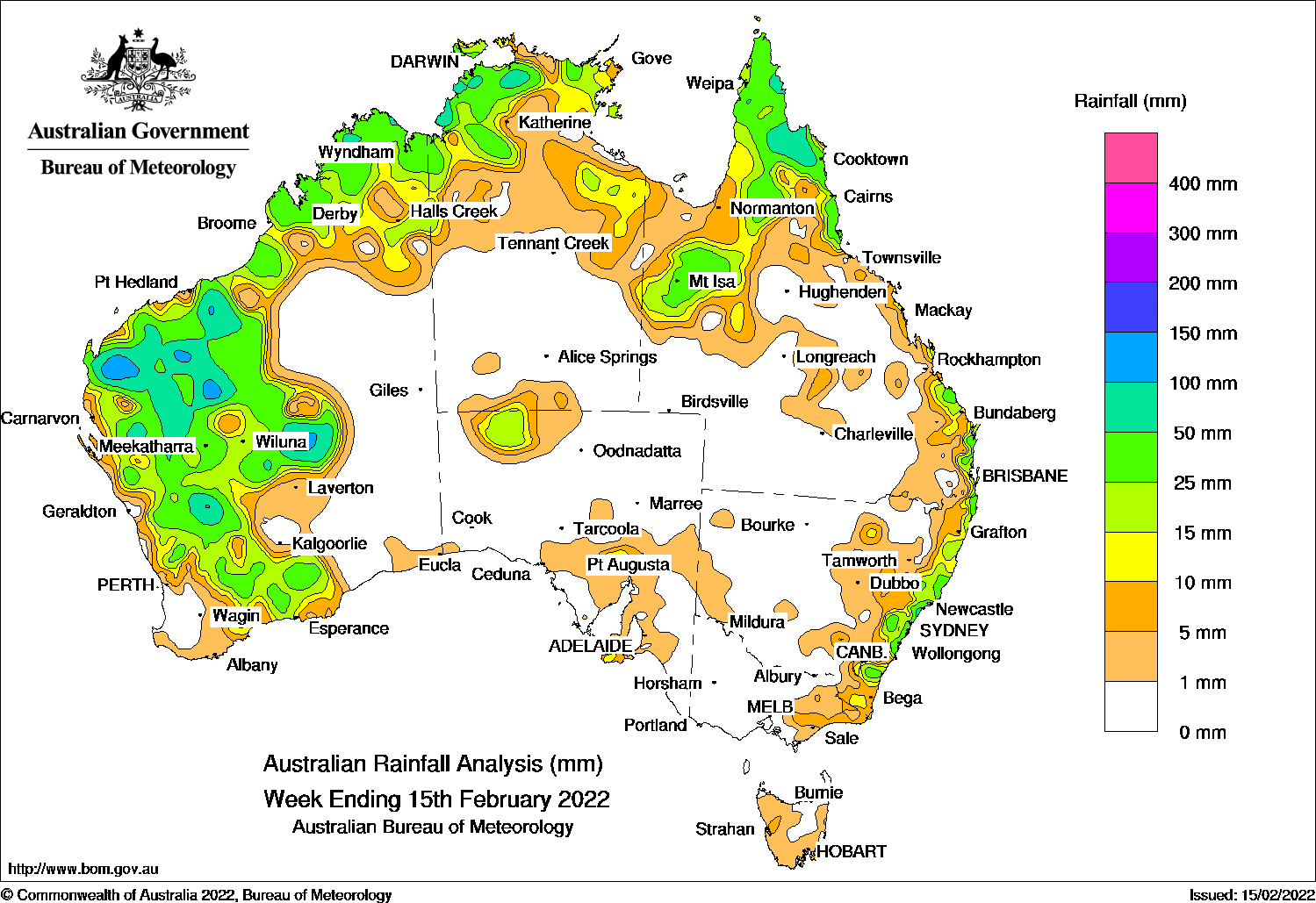
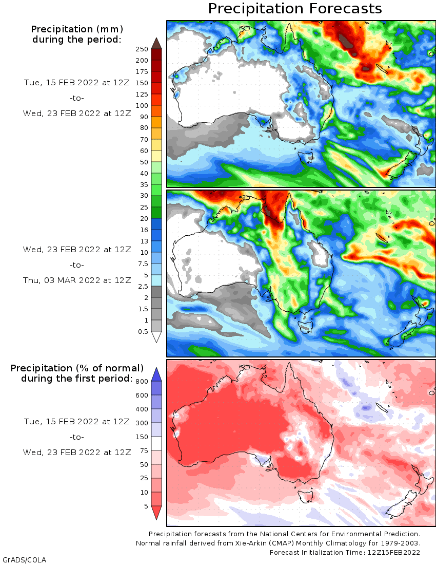
SLOW-moving thunderstorms with moderate rainfall occurred in the west of Western Australia, while thunderstorms and showers in the northern tropics and east coast of Australia.
For the week to 15 February 2022, rainfall was recorded in the Kimberley and the western two-thirds of Western Australia, the north of the Northern Territory, northern, central and coastal south-east of Queensland, and along the coast of New South Wales. Mostly light rainfall was also recorded in small areas in the north-west and south of South Australia, and parts of Tasmania.
At the start of the week, troughs extended across the north and central Australia, and a cold front brushed the south-east South Australia. Thundersorms and showers were recorded in the Pilbara and Kimberley in Western Australia, the north-western Northern Territory, the tip of Cape York in Queensland, and the north-west and south of South Australia.
During the middle part of the week, a trough developed in the west of Western Australia. Widespread thunderstorms and showers were recorded in the Pilbara, Gascoyne, and the South West Land Division (SWLD) away from the west coast. Areas in the Pilbara recorded daily rainfall of 60 mm to 90 mm.
A trough combined with onshore flow also generated thunderstorms and showers in the south and central coast of New South Wales. Daily rainfall between 50 mm and 70 mm was reocrded in the Hunter Distict. Seasonal thunderstorms with moderate rainfall were recorded in the Cape York Peninisual in Queensland.
During the last part of the week, a trough deepended in the west, and another trough extended from the Kimberley in Western Australia and the inland Northern Territory to western Queensland. Thunderstorms and showers persisted in the Pilbara and Gascoyne, and expanded to the northern Goldfields, northern and eastern SWLD.
Thunderstorms and showers were also reported in the Kimberley, the north Northern Territory and western Queensland. An onshore flow generated thunderstorms and showers along the north and south-east coast of Queensland.
For the week as a whole, rainfall totals between 50 mm and 100 mm were recorded in parts of the Pilbara, inland Gascoyne and northern Goldfields districts, pockets of the northern and eastern SWLD in Western Australia; some small pockets of the Top End of the Northern Territory; and an area on the east coast of Capr York Peninsula in Queensland. The highest weekly rainfall was 126.3 mm at Emu Creak Station in the Pilbara in Western Australia.
Rainfall totals of 10 mm to 50 mm were recorded in the Kimberley, and surrounding areas of higher falls in the remainder of the the western two-thirds of Western Australia; northern parts of the Northern Territory; much of far northern, inland north-west, and along the east coast of Queensland; along the coast of New South Wales; and areas in the north-west and south of South Australia.
Highest weekly totals
New South Wales and Australian Capital Territory
73 mm Wyong (Olney Forest)
70 mm Byron Bay (Jacaranda Drive), Old Bar (Ondarro Crest)
Victoria
16 mm Mount Moornapa, Mount Baw Baw
13 mm Gabo Island Lighthouse
Queensland
78 mm Port Douglas – Warner St
74 mm Lockhart River Airport, Tully Sugar Mill, Lotus Bird Lodge
Western Australia
126 mm Emu Creek Station
120 mm Marble Bar
113 mm Tangadee
South Australia
38 mm Port Lincoln
17 mm Ernabella (Pukatja)
14 mm Parndana (Turkey Lane)
Tasmania
14 mm Gray (Dalmayne Rd)
13 mm Lake Margaret Dam
9 mm Lake Margaret Power Station, Queenstown (South Queenstown)
Northern Territory
95 mm Port Keats Airport
94 mm Labelle Downs
82 mm Channel Point
These rainfall totals are based on real-time rainfall reports, and only limited quality control has been performed on the data. Some station names have been shortened by taking away words such as post office and airport.


HAVE YOUR SAY