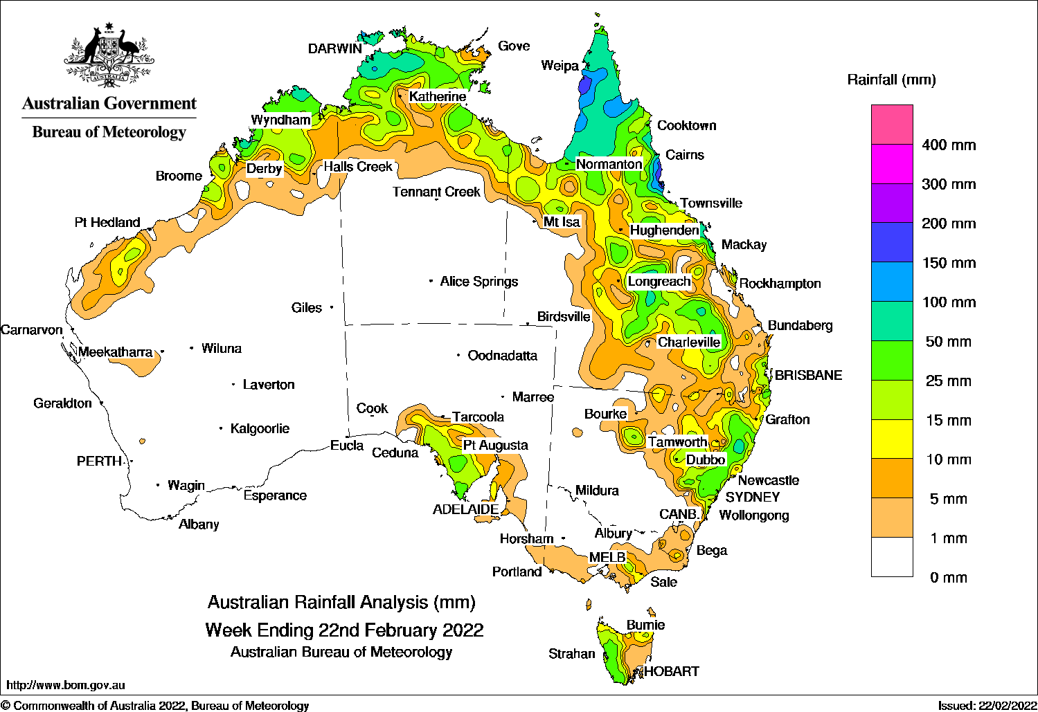
THUNDERSTORMS and showers in the northern tropics and east of Australia, while an onshore flow produced moderate to locally heavy falls on the northern Queensland coast.
At the start of the week, a middle to upper level trough produced moderate rainfall in the western agricultural districts in South Australia, while a weak cold front generated mostly light falls in the eastern Victoria and Tasmania.
An onshore flow procuded three days of moderate to locally heavy rainfall in the North Tropical Coast and the Herbert & Lower Burdekin districts in Queensland. Daily rainfall totals of 100 mm to 160 mm were recorded in and around Ingham on the 16th. Moderate rainfall was also recorded along the central Queensland coast and the Upper Flinders region.
Isolated thunderstorms and showers were recorded along the northern Australia coast.
During the middle part of the week, a trough extended across northern and eastern Australia. Thunderstorms and showers were reocrded in the Kimberley in Western australia, the northern Northern Territory, the Cape York Peninsula, the north-west and central Queensland, and the north-east New South Wales.
At the end of the week, a trough in the eastern mainlands combined with a trough over the north-east New South Wales, to produced widespread thunderstorms and showers in the north-east and central of that state, while showers contracted in the central Queensland.
A monsoonal flow to the north of Australia saw showers increased in the north-west Northern Territory, and the Cape York Peninsula in Queensland. A couple of weak cold fronts brought mostly light falls to the far south-east Austalia.
For the week as a whole, rainfall totals between 50 mm and 100 mm were recorded in the north-west Top End in the Northern Territory; the Cape York Pennisula, the North Tropical Coast and the Herbert & Lower Burdekin districts, and the central parts in Queensland; in the north and central coast and the adjecent Tablelands in New South Wales. Spots in the western Tasmania and the Kimberley in Western Australia also recorded similar weekly rainfall totals. The highest weekly rainfall total of 258.6 mm was recorded at Gairloch in the Herbert & Lower Burdekin District in Queensland.
Rainfall totals of 10 mm to 50 mm were recorded in the Kimberley, and parts of the Pilbara in Western Australia; the north of the Northern Territory; northern, central and coastal south-east of Queensland, the coastal and inland to the central and northern slopes in New South Wales; the western half of and the north-eastern Tasmania; the South and West Gippsland District in Victoria.
Highest weekly totals
New South Wales and Australian Capital Territory
88 mm Yarras (Mount Seaview)
73 mm Yarrowitch (Benditi)
71 mm Yarrowitch (Rushbrook)Box Hill (Mccall Gardens)Cranky Corner (Tangory Mountai
Victoria
30 mm Erica (Parkers Corner)
28 mm Mount Baw Baw
22 mm Giffard
Queensland
259 mm Gairloch
257 mm Tully Sugar Mill
214 mm Hawkins CreekBabinda Post Office
Western Australia
52 mm Kalumburu
50 mm Yampi Sound (Defence)
45 mm Kimbolton
South Australia
37 mm Cummins Aero
36 mm North Shields (Port Lincoln Aw
35 mm Minnipa Pirsa
Tasmania
76 mm Mount Read
71 mm Lake Margaret Dam
56 mm Lake Margaret Power Station
Northern Territory
146 mm Batchelor Airport
123 mm Kangaroo Flats (Defence)
119 mm Pirlangimpi Airport
These rainfall totals are based on real-time rainfall reports, and only limited quality control has been performed on the data. Some station names have been shortened by taking away words such as post office and airport.


HAVE YOUR SAY