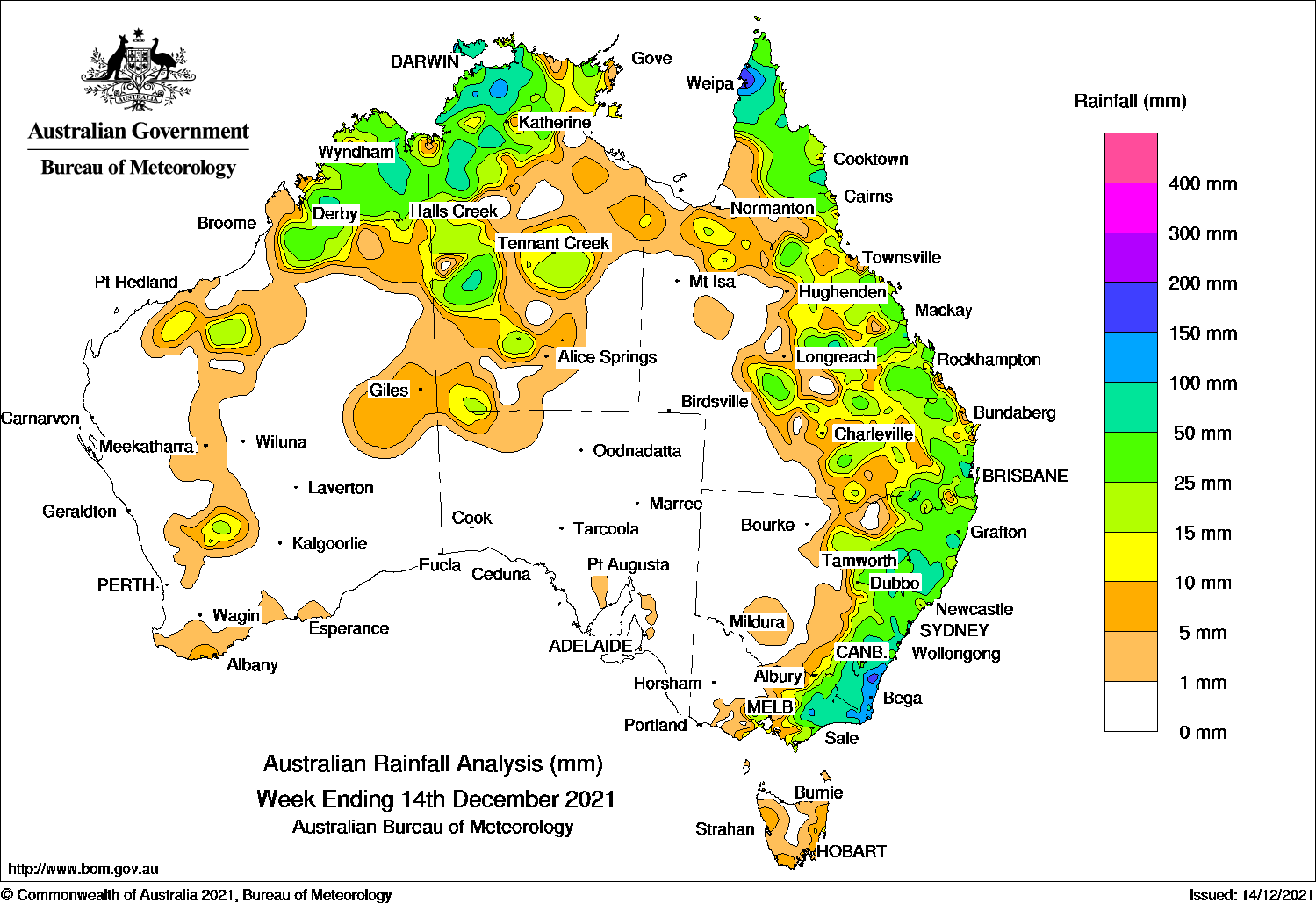
TROUGHS produced thunderstorms and showers across northern and eastern Australia, and a low pressure system generated moderate falls in south-east New South Wales.
At the start of the week, a cloud band with embedded thunderstorms stretched from northern Queensland to eastern Victoria, east of a surface trough which extended from north-western and central Queensland, through inland New South Wales to east Gippsland in Victoria. A broad trough also extended across northern and western Australia. Thunderstorms developed in central and northern Western Australia, and across large parts of the Northern Territory.
Thunderstorms and showers with moderate falls were again recorded across northern Australia extending from the Kimberley, the north and central Northern Territory and into north-eastern Queensland. The surface trough in the east triggered further showers and thunderstorms over central to south-eastern districts of Queensland.
The trough brought unsettled conditions to eastern New South Wales as it moved to the coast and weak low pressure system then formed off the southern coast of New South Wales , generating areas of heavy rainfall, with daily rainfall totals in excess of 100 mm in some parts of the south coast district in New South Wales on the 10th.
In the last part of the week, the low pressure system moved south-east away from the coast of New South Wales, and produced further moderate falls across the south coast district. The surface trough along the east coast of Queensland triggered showers and thunderstorms about the central coast and Capricornia districts, as well as across the far Cape York Peninsula.
Thunderstorms and showers continued across northern Australia to the end of the week, with isolated showers and thunderstorms developing over the Interior of Western Australia and south-west parts of the Northern Territory. Tropical cyclone Ruby formed in the Coral Sea on the 12th, then moved south-east out of the Australian region into the South Pacific region on the 13th.
Rainfall totals in excess of 100 mm were recorded in pockets of the Darwin-Daly District in the Northern Territory, around Weipa on the Cape York Peninsula, the south coast district in New South Wales and in east Gippsland in Victoria. The highest weekly total was 215.2 mm at Brogo (Blanchards Road) in the south coast district of New South Wales.
Rainfall totals between 50 mm and 100 mm were recorded in parts of the Kimberley in Western Australia, and in areas of the north-west and central west of the Northern Territory. Similar totals were reported in areas of northern, central and south-east Queensland, along much of eastern New South Wales, and the eastern third of Victoria.
Rainfall totals of 10 mm to 50 mm were recorded in northern and central Western Australia, northern and central parts of the Northern Territory, northern and the eastern half of Queensland, eastern New South Wales, and the eastern half of Victoria.
Highest weekly totals
New South Wales and Australian Capital Territory
215 mmBrogo (Blanchards Road)
204 mmBettowynd (Nobbys Hill)
164 mmMoruya (Burra Creek)
Victoria
138 mmMount Moornapa
137 mmMallacoota
109 mmGabo Island Lighthouse
Queensland
184 mmScherger RAAF
175 mmWeipa Aero
120 mmMoreton Telegraph Station
Western Australia
72 mmMarion DownsNapier Downs
70 mmKachana
South Australia
4 mmKapunda West (Kaplee)
3 mmErnabella (Pukatja)Ashton
Tasmania
16 mmGray (Dalmayne Rd)
15 mmMount Read
14 mmSwansea (Francis Street)
Northern Territory
134 mmMount Bundey South (Defence)
133 mmAdelaide River Post Office
128 mmPirlangimpi Airport
These rainfall totals are based on real-time rainfall reports, and only limited quality control has been performed on the data. Some station names have been shortened by taking away words such as post office and airport.
HAVE YOUR SAY