Drier May to July likely for southern two-thirds of Australia
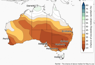
May to July rainfall is likely to be below average over the southern two-thirds of mainland Australia, according to the latest Seasonal Climate Outlook statement released this morning by the Bureau of Meteorology.
Chances of a drier three months are highest in southeast Australia, where there is a greater than 75% chance that the season will be below average.
May is likely to be drier than average across most of Australia, except far northern Australia and Tasmania.
This outlook is influenced by warming in tropical Pacific sea surface temperatures and a cooler eastern Indian Ocean.
Historical outlook accuracy for May to July is moderate over most of eastern Australia and WA, but is lower in patches across the central south, and the tropical north. See map for more detail.
Warmer days likely for much of Australia, but cooler for NT’s Top End

Daytime temperatures for May to July are likely to be above average for most of Australia, but below average for the Top End of the NT.
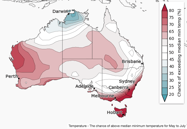
Night-time temperatures for May to July are likely to be warmer for southwest and central Australia, as well as far southeastern parts of Australia. The Top End of the NT is likely to have cooler nights for May to July.
This outlook is influenced by warming in tropical Pacific sea surface temperatures and a cooler eastern Indian Ocean.
Historical maximum temperature accuracy for May to July is moderate to high over most of Australia.
Minimum temperature accuracy is moderate for most of Australia, except for parts of southeastern Australia, where accuracy is low to very low.
Source: Bureau of Meteorology
Comparison – previous outlook versus actual rainfall
Scroll between maps below to compare BOM’s rainfall forecast for January to March 2017, released in mid-December 2016, with actual rain that fell over the January to March 2017 period.


I hope they are actually right, after all the rain we’ve had the last three months that they predicted we wouldn’t get.