Drier July to September likely for parts of southern Australia
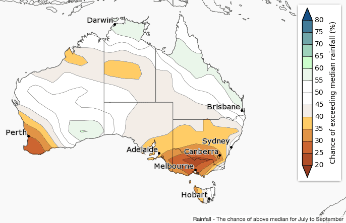
July to September rainfall is likely to be below average over southwest WA and southeast Australia, according to the latest climate outlook statement released by the Bureau of Meteorology today.
A drier than average July is likely over southwest WA, and eastern NSW. Elsewhere, there are roughly equal chances of a wetter or drier month.
Higher than average mean sea level pressure is anticipated over southern Australia during July to September, which is likely to keep frontal systems and lows further south than usual, and reduce cloudiness over land.
Historical outlook accuracy for July to September is moderate over most of Australia, but low near the WA border and central SA. See map for more detail.
Warmer July to September days and nights for most of Australia

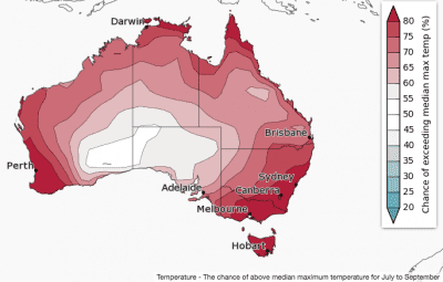
 July to September daytime temperatures are likely to be warmer than average for most of Australia, except for southeast WA and western and central SA.
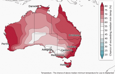
July to September nights are likely to be warmer than average for Australia, except over northwest and southeast SA and adjacent border areas.
While nights are likely to be warmer on average, very cold nights also remain likely during periods of high pressure and clear skies—watch local forecasts and warnings.
Chances of warmer days and nights are highest in the southwest, southeast and northeast, where there is a greater than 80% chance of warmer than average days and nights.
Historical maximum temperature accuracy for July to September is moderate to high over most of Australia. Minimum temperature accuracy is moderate over northern Australia and Tasmania, but low elsewhere.
Comparison – previous outlook versus actual rainfall
Scroll between maps below to compare BOM’s rainfall forecast for March to May 2017, released in mid-February 2017, with actual rain that fell over the March to May 2017 period.


HAVE YOUR SAY