Mostly neutral start to 2016, but reduced wet season rains likely in the north
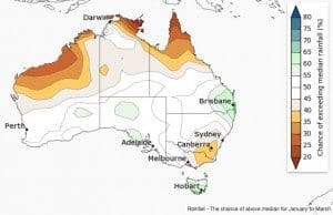
For most of Australia the chance of above or below average January rainfall is roughly equal, with below average rainfall more likely in patches of western WA, the far tropical north and the southeast, according to the Bureau of Meteorology’s latest seasonal climate outlook report.
The Bureau says the first three months of 2016 are likely to be drier than average across parts of northern Australia, and the southeast mainland. Conversely, southeast Queensland and Tasmania are likely to be wetter than average.
Current climate influences include a combination of a strong El Niño in the Pacific and very warm Indian Ocean temperatures.
Historical outlook accuracy for January to March rainfall is moderate over most of Australia, except southern parts of WA, and parts of the interior where accuracy is low to very low.
Cooler start to 2016 likely for southeast Australia; warmer elsewhere

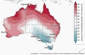
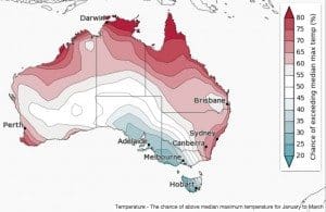
 January is climatologically the warmest month of the year for Australia. The outlook for January shows maximum and minimum temperatures are likely to be warmer than normal across northern and eastern Australia, and WA. Conversely, days and nights are likely to be cooler during January in parts of the southeast.
January to March daytime and night-time temperatures are likely to be cooler than average across the southeast, including southeast SA, southwest NSW, western to central Victoria and most of Tasmania. Elsewhere, temperatures are likely to be warmer than average.
Current climate influences include a combination of a strong El Niño in the Pacific and record-warm temperatures in the Indian Ocean.
Maximum temperature accuracy is moderate over most of Australia except eastern SA where accuracy is low. Minimum temperature accuracy is patchy, with moderate skill across eastern Australia, the Top End of the NT, and eastern WA.


HAVE YOUR SAY