 ALMOST all of New South Wales remains in drought despite recent rainfall, and large parts of southern Australia face above normal bushfire potential over the coming months.
The NSW Department of Primary Industries today released the latest State Seasonal Update, which indicated NSW received welcome widespread rainfall throughout August; however 99.8 percent of NSW remained in drought.
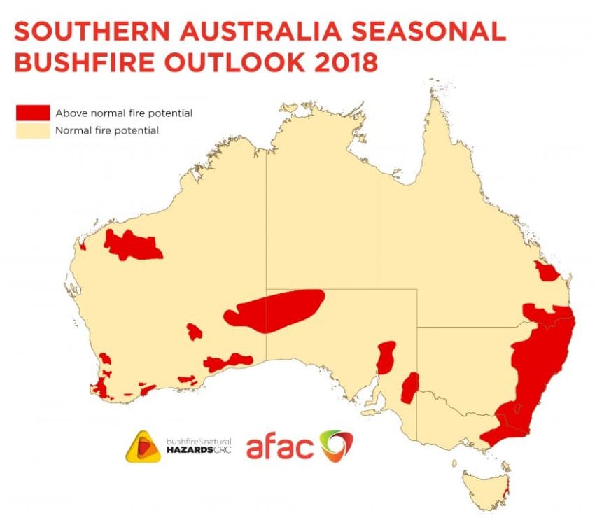
And the Bushfire and Natural Hazards CRC this week released the Southern Australia Seasonal Bushfire Outlook 2018 which showed fire potential across New South Wales, the ACT, Victoria, Tasmania, South Australia and southern Western Australia and Queensland.
NSW DPI’s leader of climate applications and digital agriculture, Dr Anthony Clark said the recent rainfall is a positive start but totals were still average to very much below average across most of the state and drought conditions continue to be experienced.
“Significant falls occurred for parts of the Central Tablelands, North Coast, Northern Tablelands and a small area of the Western region around Bourke.
“Reasonable falls were also recorded to the north of the South East region, the east of the Murray and Riverina regions as well as north of Singleton in the Hunter region,” Dr Clark said.
While August rainfall has provided a more positive outlook for NSW primary producers, there are still areas of ongoing concern and the forecast from the Bureau of Meteorology currently points to a higher chance of warm, dry conditions in spring.
“Parts of the state had minimal rainfall throughout August including much of the Western region, the western area of the Central West region, the area around Walgett in the North West region and areas south of Singleton in the Hunter received little to no rainfall,” he said.
“These areas have been managing drought conditions for some time now, with the event duration now near, or in some cases, over twelve months.
“While the rain has been welcomed and has provided a more positive outlook for field conditions in some regions, the drought is far from over,” Dr Clark said.
“We need more significant widespread rainfall in the coming weeks and months for agricultural recovery to commence and farmland to return to a productive state; however, if the forecasted conditions eventuate we would see an increased intensification of the drought.”
For more information visit, www.droughthub.nsw.gov.au
Southern Australia expected to see more bush fires earlier
The Bushfire and Natural Hazards CRC said with much of southern Australia experiencing a combination of above average temperatures and below average rainfall this year, combined with the forecasts for spring, suggest that the southern fire season is likely to commence earlier than usual and be more active than normal.
The Southern Australia Seasonal Bushfire Outlook 2018 is used by fire authorities to make strategic decisions on resource planning and prescribed fire management for the upcoming fire season. The outlook is developed at an annual workshop convened by the Bushfire and Natural Hazards CRC and AFAC. The workshop discussed the weather, landscape conditions and cross-border implications leading into summer and determined areas that had the potential for a fire season that was above normal, normal or below normal.
The Outlook map shows the bushfire outlook for southern Australia through to the end of 2018. This map has been combined with the outlook for the northern Australia bushfire season, which was released in July, to show the areas of fire potential for all of Australia. (See Hazard Note 49, July 2018).
The outlook will be reviewed towards the end of spring to take into account the impacts of actual temperatures and rainfall in the lead up to summer. See the full Southern Australia Seasonal Bushfire Outlook here: http://www.bnhcrc.com.au/hazardnotes/51

HAVE YOUR SAY