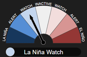
AUSTRALIA’S Bureau of Meteorology has moved to a La Niña Watch, after some early signs that a La Niña might form in the Pacific Ocean later in 2024.
However, the bureau said the El Niño–Southern Oscillation (ENSO) is currently neutral and it is important to note there is a similar likelihood that the tropical Pacific Ocean will remain neutral.
 Moving to La Niña Watch does not mean that the bureau is declaring that a La Niña event is underway, the bureau said.
Bureau of Meteorology climate manager Dr Karl Braganza said rainfall and temperature forecasts are not based on the status of the El Niño–Southern Oscillation Outlook.
“The best guidance for future rainfall or temperature forecasts is the bureau’s long-range forecast. The bureau’s long-range forecast winter outlook will be released at the end of May, while the Spring and Summer outlooks will be released later in the year.
“The long-range forecast for June to August is showing an increased chance of above average rainfall for parts of eastern Australia, and parts of Western Australia and South Australia,” Dr Braganza said.
“There are roughly equal chances of above or below median rainfall for most of eastern Australia, including much of Queensland, New South Wales, Victoria and Tasmania.”
June to August maximum and minimum temperatures are very likely to be above median across all States and Territories, the bureau said.
La Niña, along with El Niño, is part of a natural climate cycle known as the El Niño–Southern Oscillation (ENSO).
It’s a 50:50 chance
The bureau said when La Niña Watch criteria have been met in the past, a La Niña event has subsequently developed around 50 percent of the time. There is about an equal chance of neutral ENSO conditions in the same outlook period.
Sea surface temperatures in the central Pacific have been steadily cooling since December 2023. This surface cooling is supported by a significant amount of sub-surface cooling in the central and eastern Pacific. Recent cloud and surface pressure patterns are ENSO-neutral.
The bureau said its modelling suggests that ENSO will likely remain neutral until at least July 2024. It is important to emphasise that early signs of La Niña are most relevant to the climate of the tropical Pacific, and that the long-range forecast for Australian rainfall and temperature provides better guidance for local climate, it said.
The bureau said the Indian Ocean Dipole (IOD) is currently neutral. The most recent two weeks have seen the IOD index within neutral thresholds, and follow seven weeks of the index being above the positive IOD threshold (+0.40 °C). The current SST observations suggest that recent development of a positive IOD may have stalled. If a positive IOD eventually develops, it would be earlier in the calendar year than is typical historically.
The bureau said global sea surface temperatures (SSTs) have been the warmest on record for each month between April 2023 and April 2024, with April 2024 SSTs warmer than April 2023. The global pattern of warmth is affecting the typical historical global pattern of sea surface temperatures associated with ENSO and IOD variability. As the current global ocean conditions have not been observed before, inferences of how ENSO or IOD may develop in 2024 that are based on past events may not be reliable.
The Southern Annular Mode (SAM) is currently neutral (as at 13 May). Forecasts indicate the index is mostly likely to remain neutral or become positive in the coming fortnight.
The Madden–Julian Oscillation (MJO) is currently weak. Most models forecast indicate that the MJO will remain weak before re-strengthening over the eastern Indian Ocean or Maritime Continent region from mid- to late-May, the bureau said.
Source – Bureau of Meteorology.

HAVE YOUR SAY