THUNDERSTORMS brought rainfall to the Kimberley and northern parts of the Northern Territory, while showers and thunderstorms produced light to moderate falls from north-west Queensland to north-eastern and central coastal areas of New South Wales.
The highest weekly total was 95 mm at Fish River in the Darwin–Daly region of the Northern Territory.
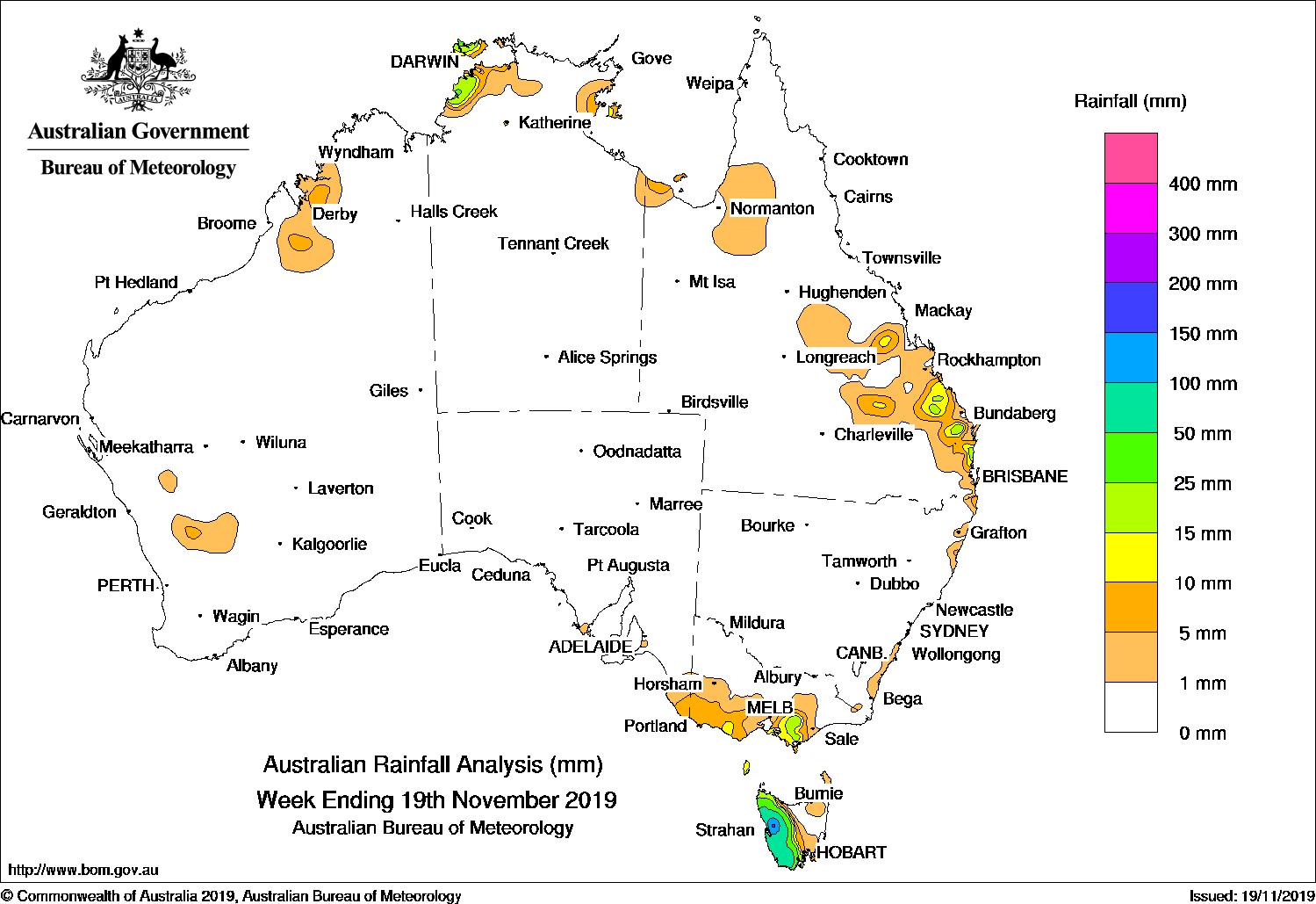
Past seven days: For the week to 26 November 2019, rainfall was recorded in the Kimberley and the northern parts of the Northern Territory, north-west and southern inland Queensland, north-eastern and the central coast of New South Wales, along the southern coast of Western Australia, south-eastern South Australia, southern Victoria and Tasmania.
At the start of the week, a cold front tracked across southern Western Australia, generating light falls. Broad areas of low pressure extended along northern Australia, with isolated thunderstorms over the Kimberley, Top End in the Northern Territory, and in north-west Queensland.
By the middle of the week, a surface trough across northern Australia deepened, and also extended down through inland Queensland and into north-eastern New South Wales, generating thunderstorms and moderate falls in the Kimberley, in northern parts of the Northern Territory, about the Gulf Country and in south-west Queensland.
The surface trough lingered through inland parts of Queensland and north-eastern New South Wales, with thunderstorms and showers developing through Queensland’s interior, and across parts of north-eastern and the central coast of New South Wales, with some moderate falls reported. Thunderstorms were also producing moderate falls in the Kimberley and around northern parts of the Northern Territory, while isolated thunderstorms developed through the interior of Western Australia for the rest of the week.
At the end of the week, a pair of cold fronts tracked across southeast Australia, with light moderate falls recorded in Tasmania, and light falls in south-eastern South Australia, and in south-western and southern Victoria.
Rainfall totals in excess of 50 mm were recorded around the Darwin–Daly region in the Northern Territory and in the Kimberley in Western Australia. The highest weekly total was 95 mm at Fish River in the Northern Territory.
Rainfall totals in excess 25 mm were recorded across the northern Kimberley, in parts of the Top End in the Northern Territory except around Arnhem Land, in parts of the north-west and southern interior of Queensland, areas in north-eastern New South Wales, and in an area of western Tasmania.
Rainfall totals between 10 mm and 25 mm were recorded in the far southwest and Kimberley in Western Australia; across most of the Top End in the Northern Territory, except in Arnhem Land; in the northwest, central west and southern interior of Queensland; in parts of northeastern and the central coast of New South Wales, and in areas of Tasmania.
Little or no rainfall was recorded in remaining parts of Western Australia, the southern two-thirds of the Northern Territory, most of South Australia, in the far southwest and east coast of Queensland, western and southern New South Wales, and in northern and eastern Victoria.
Highest weekly totals
New South Wales and Australian Capital Territory
52 mm Moppy Lookout (Barrington Tops)
50 mm Wilsons Downfall
47 mm St Ives (Richmond Avenue)
Victoria
12 mm Kinglake West
9 mm Ferny Creek
7 mm Multiple locations
Queensland
50 mm Mt Moffatt National Park
33 mm Havelock
31 mm Munnaweena
Western Australia
55 mm Kachana
46 mm Drysdale River Station
40 mm Argyle Aerodrome
South Australia
7 mm Robe
6 mm Mount Gambier Aero
3 mm Nangwarry Forestry SA DepotKingston SECape Jaffa (The Limestone)
Tasmania
39 mm Huonville (Tutton Avenue)
32 mm Mount Read
28 mm Lake Margaret Dam
Northern Territory
95 mm Fish River
83 mm Kangaroo Flats (Defence)
71 mm Adelaide River Post Office
Rainfall outlook
HAVE YOUR SAY