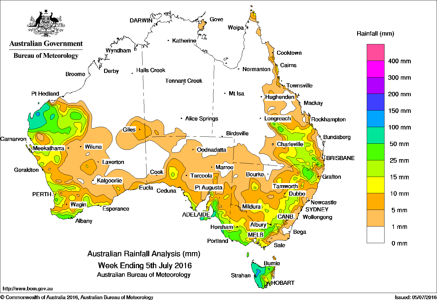
Rainfall in the past week was recorded in the west and south of Western Australia, southern parts of South Australia, Victoria, New South Wales, Tasmania, and in southeastern and the north tropical coast of Queensland.
At the start of the week, moderate falls were recorded in Tasmania from a westerly flow, while a cold front and an associated cloudband moved through southwest Western Australia and produced light to moderate falls in the Gascoyne and parts of the South West Land Division.
During the middle of the week, the frontal system and associated low moved across South Australia and southeastern Australia. Mostly light rainfall was recorded in southeastern South Australia. Moderate rainfall totals were recorded in western, central and northeastern Victoria, extending into the Snowy Mountains in New South Wales. Northern and western Tasmania also received moderate to heavy falls. A cloudband brought moderate falls to parts of the Pilbara and Gascoyne.
In the last part of the week, a cold front and associated cloudband extended from southwest Western Australia to a low south of Tasmania. Moderate falls were recorded along parts of the southern coast of Western Australia, the Northwest Pastoral district in South Australia, and in Tasmania. As the cold front moved over coastal South Australia, a low pressure system developed in the State’s southeastern border, producing moderate to heavy falls in the Mount Lofty Ranges and southeastern South Australia. The deepening low and fronts moved over inland eastern Australia and brought moderate falls to southeast and central Queensland, and central and northeastern New South Wales.
A cloudband over the west of the continent generated moderate falls across the Pilbara and northwest Gascoyne coast. A moist, onshore southeasterly flow brought persistent shower activity to Queensland’s north tropical coast during the week.
Rainfall totals between 50 and 100 mm were recorded in western Tasmania, parts of the Gascoyne and Pilbara coasts in Western Australia and southeast South Australia, including Kangaroo Island. Falls in excess of 100 mm were recorded in small pockets of the Pilbara coast, the exposed coast of southeast South Australia, and in northwestern Tasmania. The highest weekly total was 198 mm at Mount Read in western Tasmania.
Rainfall totals between 10 mm and 50 mm were recorded across large parts of the west and south of Western Australia, the Northwest Pastoral district and southeast South Australia, and in the southwest, central and northeastern parts of Victoria. Similar totals were recorded in the Tablelands, and in northeastern and central New South Wales, and in southeastern Queensland.
Remaining parts of Western Australia, the Northern Territory, and most of Queensland away from the southeastern quarter recorded little or no rainfall this week.
Highest weekly totals in each State and Territory:
New South Wales and Australian Capital Territory
50 mm Kings Plains (Windermere)
46 mm Glen Innes Airport AWS
42 mm Haystack (Beardy River)
Victoria
88 mm Grampians (Mount William)
73 mm Haines Junction (Mount Sabine)
55 mm Beech Forest
Queensland
44 mm Beardy Junction
35 mm Tarome
32 mm Mantuan Downs
Western Australia
118 mm Mardie
99 mm Onslow Airport
76 mm Barrow Island Airport
South Australia
109 mm Myponga
104 mm Parawa (Sharon)
97 mm Parawa
Tasmania
198 mm Mount Read
114 mm Queenstown (South Queenstown)
111 mm Waratah (Mount Road)
Northern Territory
7 mm Yulara Airport
6 mm Alcan Minesite
5 mm Yirrkala Tropical Gardens
More weekly rainfall totals:
- NSW/ACT totals click here
- Vic totals click here
- Qld totals click here
- WA totals click here
- SA totals click here
- Tas totals click here
- NT totals click here
Source: BOM
HAVE YOUR SAY