IT is still too early to accurately predict the timing and magnitude of an El Niño event later this year, the Bureau of Meteorology said today.
The bureau said Australia’s rainfall is influenced by more than just the El Niño–Southern Oscillation, or ENSO. Factors like the Indian Ocean Dipole, localised sea surface temperatures, and long-term climate trends also play a role.
The El Niño–Southern Oscillation (ENSO) is currently neutral – neither La Niña nor El Niño. While models suggest a possible shift to El Niño later this year, its timing and strength is less certain, the bureau said.
The bureau said its long-range forecast is the best guide to Australia’s likely rainfall and temperature patterns in the coming months. It responds to all the ongoing changes in our climate systems and is updated regularly.
 The bureau said sea surface temperatures in the central tropical Pacific have been progressively warming recently.
Bureau and other models forecast the tropical Pacific to continue warming in the coming months to reach levels consistent with El Niño. The models vary in the timing at which El Niño thresholds may be reached. Some suggest as early as May, while others show a slower warming with thresholds not being met until July, the bureau said.
However, sea surface temperatures are only one indicator of ENSO events.
The bureau said it would also need to see signs that the atmosphere is shifting towards El Niño levels including trade winds, pressure and cloud patterns. This ocean-atmosphere coupling (where the ocean and atmosphere act to reinforce each other) is required for a sustained El Niño state.
At this time of the year, forecasts for ENSO conditions in winter and spring are typically less certain due to the autumn predictability barrier. This means it is too early to assign high confidence to the forecasts, the bureau said. Watch a video about Understanding the El Niño–Southern Oscillation.
The bureau said rather than being classified as rare or unusual, El Niño and La Niña events are part of a natural cycle in the Pacific Ocean that can affect global weather. There is a chance that models can overestimate seasonal fluctuations in the oceans and atmosphere when looking too far ahead. The bureau expects a clearer picture later in autumn.
May to July forecast
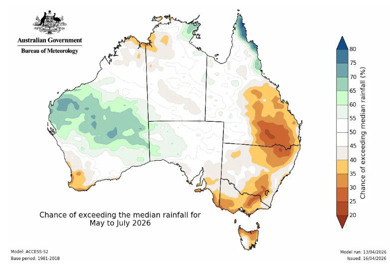
The bureau said its first look long-range forecast for May to July 2026, issued 16 April, showed:
rainfall is likely to be below average for parts of eastern and south-west Australia, and;
rainfall is likely to be above average across some western and central parts of Western Australia as well as parts of the east coast of Queensland’s Cape York Peninsula
For most other areas, there is no clear signal for either wetter or drier conditions, meaning there are roughly equal chances of above or below average rainfall, the bureau said..
HAVE YOUR SAY