
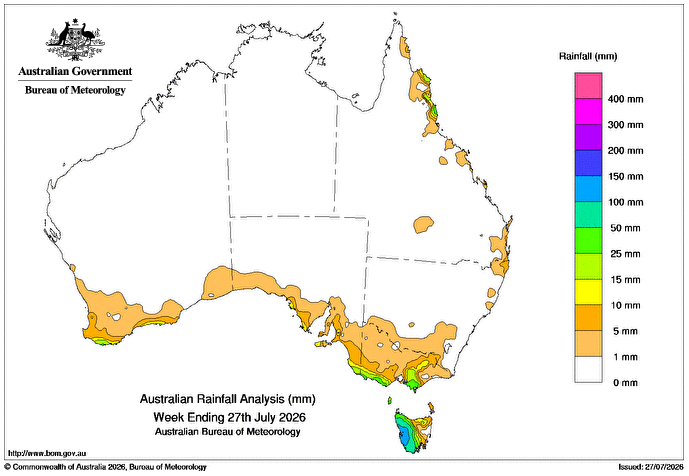
A SERIES of cold fronts and low pressure troughs has brought showers and isolated thunderstorms to south-eastern Australia in the past week.
A strong cold front on July 23 resulted in moderate to heavy rainfall in southern Victoria and western Tasmania with snow falls to alpine regions.
A warm front on July 24 and 25 continued the moderate to heavy rain in western Tasmania.
 There were weekly rainfall totals of up to 10mm with higher totals of 15-50mm in far south-eastern South Australia, southern and north-eastern Victoria, western and southern Tasmania, and higher totals over 100mm across western Tasmania.
Cold fronts clipped the south of Western Australia early in the week, with a stronger cold front on July 26 bringing rain and showers.
Weekly totals up to 10mm were recorded in parts of WA’s south-west and south coastal districts, with higher totals up to 25mm about the far south-west.
A high-pressure system that lingered in the Tasman Sea resulted in light onshore showers across the east coast most of the week.
There were weekly rainfall totals of up to 10mm, with higher totals of 25-50mm about the North Tropical Coast and Tablelands district of Queensland.
The highest weekly total at a Bureau of Meteorology gauge of 237mm was recorded at Lake Margaret River in Tasmania.
The highest daily total at a bureau gauge of 49mm was recorded at Derwent Bridge in Tasmania in the 24 hours to 9am on 25 July.
HAVE YOUR SAY