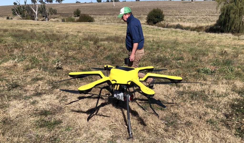
Preparing to fly the LiDAR-equipped drone over a paddock near Boorowa.
A tool originally built to improve grape quality in vineyards by aiding canopy management is being repurposed to measure pasture biomass across Australian grazing paddocks. Research suggests more accurate biomass measurement could lift livestock farm profitability by 11-15pc. The system will layer LiDAR with other sensors to work out how edible an area of pasture is….
A DRONE lifts off over a paddock in Boorowa Agricultural Research Station on a map-making mission.
At the controls, CSIRO senior research technician Stuart Brown keeps a careful eye on the attached Light Detection and Ranging (LiDAR) sensor as it fires an invisible lattice of laser pulses at the grass, building up a three-dimensional map of the paddock, one small cube of space at a time.
 Once the flight is completed, Dr Yusuke Kikuchi, a digital agronomist at CSIRO, leads the field team back to the same paddock – armed not with a drone, but with shears and scales. They cut the pasture by hand, square metre by square metre, and weigh what they find. It’s precise, painstaking work – the kind producers have had to rely on for generations.
“Graziers need to know the exact amount of living pasture biomass,” Dr Kikuchi said. “Get that figure right, and the benefits ripple outward: better-fed livestock, less risk of overgrazing and more efficient use of every paddock.”
That’s not a marginal gain for an industry so reliant on strategic grazing decisions, explained Dr Kikuchi – it’s a decision which will touch everything downstream, from animal growth rates to environmental impact.
A gap between two extremes
Principal research scientist and team leader for Agrisensing Analytics at CSIRO, Dr Everard Edwards, has watched producers try to solve this problem for years.
“Pasture biomass tends to be estimated in a couple of ways,” he said.
At one end sits freely available satellite data, feeding tools that use a measure called NDVI to estimate plant growth across a property. NDVI stands for Normalised Difference Vegetation Index, a measure derived from satellite or sensor imagery that tracks how plants reflect and absorb different wavelengths of light.
“It’s considered a reliable indicator of how much live green vegetation is present,” Dr Edwards said, “but that accuracy drops away in dense canopies, where the index quickly saturates – an issue compounded by the lack of plant height information from a satellite.”
At the other end of the scale sits hand measurements such as the rising plate meter, a tool that estimates pasture height based on a calibration curve built from many hand-cut estimates.
“Single readings are typically highly accurate, but the problem with those is they’re single point and labour intensive,” said Dr Edwards. “We are currently missing a method in-between these two opposite ends of scale.”
This was the challenge that Meat & Livestock Australia identified, describing a demand from producers for something with the reach of satellite data and the precision of a plate meter. MLA asked Dr Edwards to explore how CSIRO’s LiDAR expertise could be applied to pasture biomass.
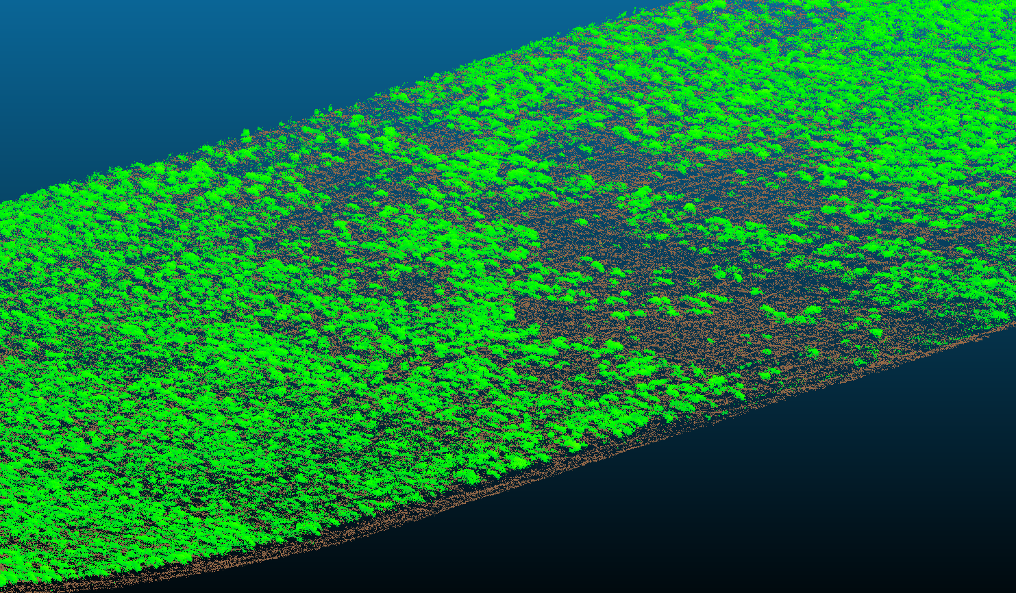
A ray cloud visualisation of a paddock, distinguishing living plant material (green) from bare ground (brown).
A tool already proven in the vineyard
It helped that Dr Edwards already knew where to start, with CSIRO having significant expertise in the use of LiDAR, a sensor developed decades ago by the aviation industry, that fires hundreds of laser pulses per second, using the time they take to bounce back to build a three-dimensional map.
Some years earlier, working with Wine Australia, Dr Edwards’ team had adapted LiDAR to measure canopy structure in vineyards using a set of tools called RayCloudTools. The commonly visualised LiDAR point cloud provides the place where each pulse ends up, but a ray cloud also stores the full path it travelled to get there, turning a static dot pattern into a record of how porous or solid a space is.
Pasture was a natural next step. The proof-of-concept project, jointly funded by MLA and CSIRO, began in January, and has already yielded promising results.
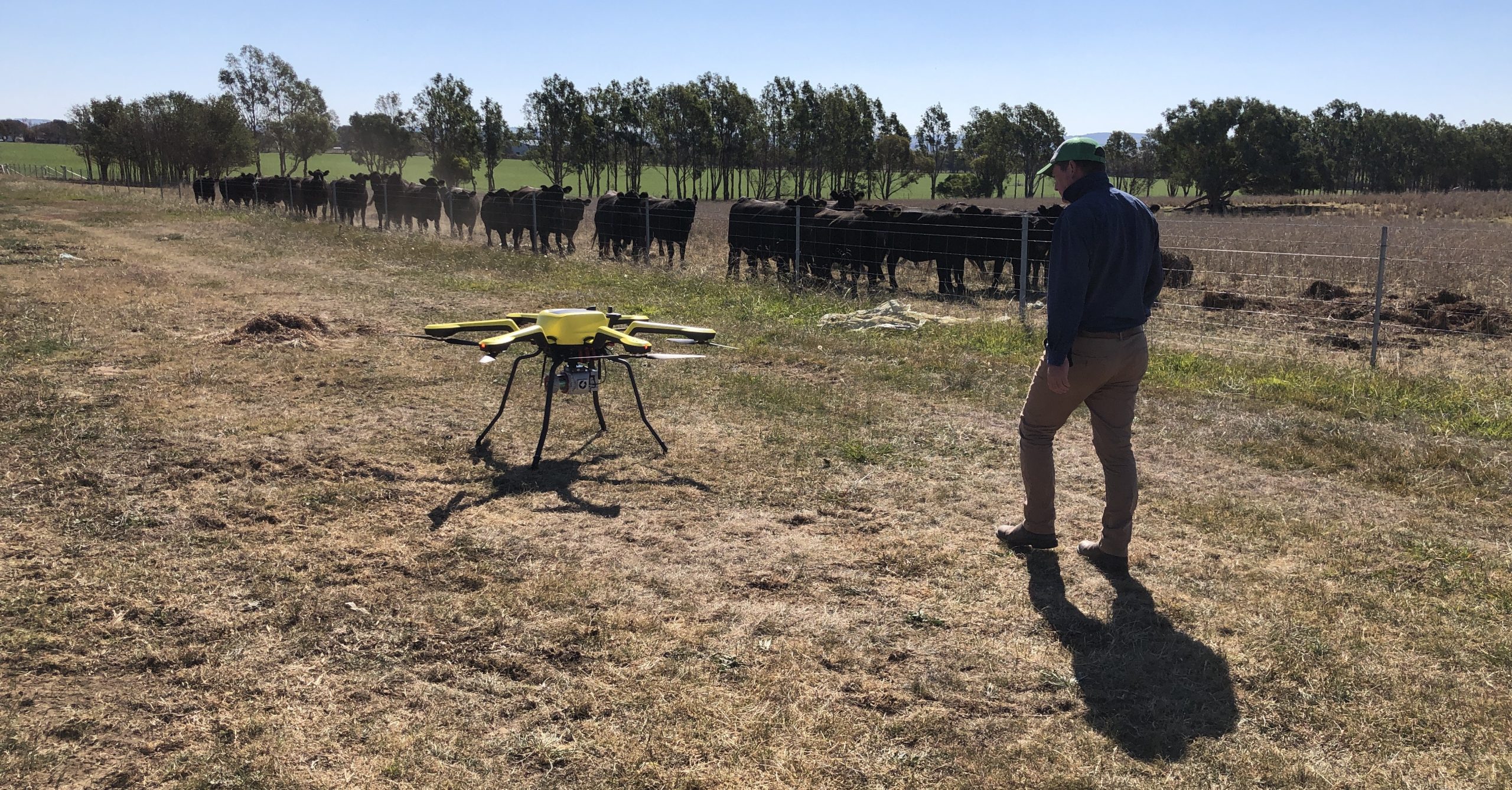
A drone waits to take off from a paddock for a test flight, with cattle gathered at the fence line beyond.
Grass is a harder problem than grapevines
Dr Kikuchi is leading the fieldwork and the adaptation of the tool from vineyard to paddock. He is discovering that the differences run deeper than scale. In the wine industry, RayCloudTools mapped canopy density above a reliable gap between vine and ground. Pasture offers no such gap: grass grows from the soil up, so separating plant from ground is the hardest technical problem in the whole system.
“Ground detection is a huge challenge for this project,” Dr Kikuchi said.
To pin it down, the team is using trial plots of pasture at CSIRO’s Boorowa research site in southwest NSW, deliberately treating pasture, slashing and grazing to create a spread of biomass levels to test the model.
They are also working through the question of which biomass actually needs to be measured: many systems apply a rule of thumb where cattle graze pasture down to about 5cm above the ground. Could the tool’s precision mean that they only track the biomass animals can actually reach?
“It’s not only the technology side of things – it also needs discussion with industry,” Dr Kikuchi said.
Teaching a laser to tell living grass from dead
LiDAR has one significant blind spot: it measures how much plant material is there, but not whether it’s alive, and for a grazing decision that matters enormously, since animals perform best on the living, green portion of a pasture.
To solve it, Dr Kikuchi is layering-in RGB and multispectral cameras to read colour and health, alongside a radar sensor to capture water content, to determine the most effective method.
Radar is sensitive to water content, being able to capture the amount of water in the pasture canopy across the paddock.
Combined, those sensors provide a proxy for separating green, living pasture from dry, standing dead matter.
The economic case is substantial: published research into pasture-based dairy systems has found that cutting the average error in herbage mass estimates to 15pc could lift farm profitability by 11-15pc.
“If you don’t overestimate the biomass, then you don’t overgraze the area by accident,” Dr Edwards said. “The more accurate it is, the more carefully cattle can be managed – and the more efficiently animals will grow.”
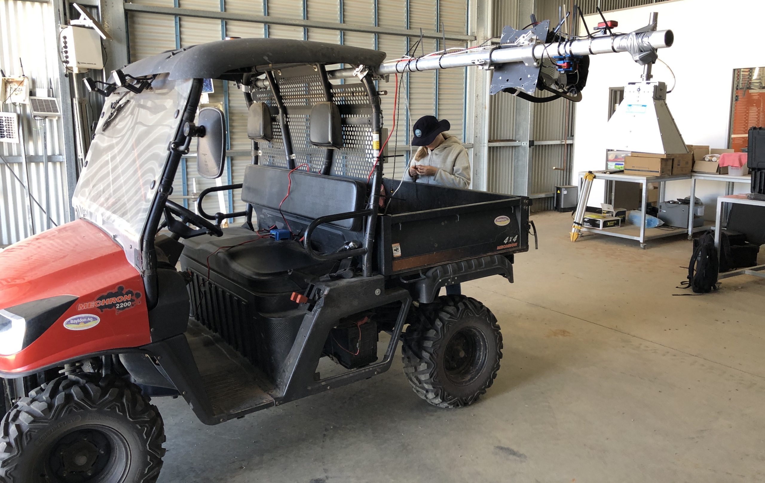
The ground vehicle-based LiDAR scanner, built onto a boom attached to a side-by-side vehicle, is prepared ahead of testing.
Testing the extremes
Both a drone-mounted system and a ground vehicle-based scanner are being trialled at Boorowa and compared for accuracy and ease of use. The team anticipates the drone will offer the more scalable option for commercial properties.
The next phase will push the tool into landscapes far removed from where it started: CSIRO’s Lansdowne site in the arid tropics near Townsville, with tall, tussocky grass over a metre high, and its Armidale site in northern NSW. Alongside commercial properties, these trials will give researchers confidence the method holds up across the extremes and diversity of Australian pasture.
That there is demand is clear. Since Dr Edwards spoke about the project at a recent industry event, several producers have approached the team directly.
“It’s exactly what they need for their systems,” he said of the response.
Behind the paddock work sits a wider CSIRO collaboration: the scanning hardware traces back to underground mining technology and radar expertise from CSIRO’s Technology and Mineral Resources research units, and livestock scientist Dr Sabrina Greenwood grounds the engineering in animal science.
If this month’s project check-point goes to plan, the team has a further year to refine the method across Australia’s varied pasture types.
Then the conversation will turn to what comes next: getting the tool into the hands of the people managing paddocks every day.
Source: CSIRO
HAVE YOUR SAY