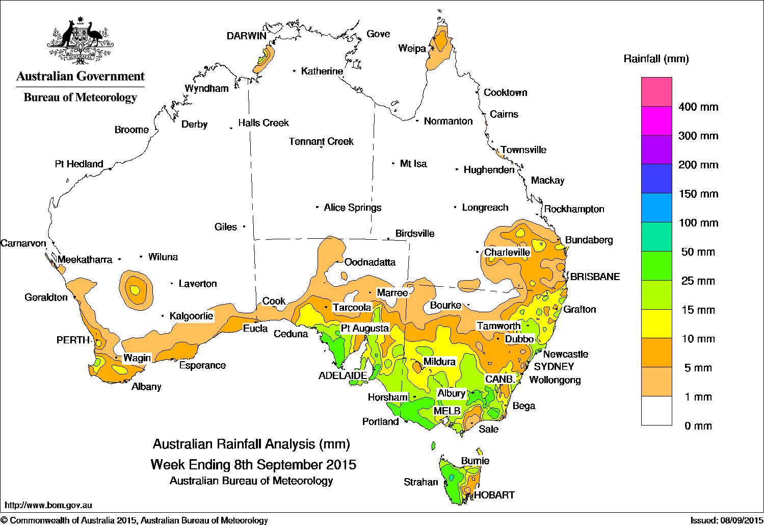
 The highest falls of the past week exceeding 50 mm were recorded in the northwest of Tasmania, and isolated parts of the Mount Lofty Ranges in South Australia, and across parts of southwest Victoria. The highest weekly total of 84 mm was recorded at Mount Sabine in western Victoria.
Rainfall totals between 10 mm and 50 mm were recorded in parts of far southwest Western Australia, in the central and southeastern parts of South Australia, most of Victoria excluding parts of south Gippsland, western and northern Tasmania, southern and northeast New South Wales, and southeastern Queensland.
The remaining area of Western Australia, nearly all of the Northern Territory, western and northern South Australia, northwestern New South Wales, and all of Queensland away from the southeast recorded little or no rainfall this week.
In the first half of the week, a low pressure system located in the Bight and an associated cold front tracked across South Australia. With a pre-frontal trough extending into central and northern Australia, and the cold front tracking eastwards across Victoria and New South Wales, moderate rainfall was recorded in western agricultural areas of South Australia. Rainfall continued across southeastern South Australia and widespread, moderate rainfall totals were also recorded in central parts of Victoria, and southern New South Wales as the low moved off the east coast and into the Tasman Sea. A trough extending from the Kimberly into southwest Queensland produced light rainfall for western parts of the Top End of the Northern Territory.
During the middle of the week, a surface trough brought light rainfall to the southern inland Gascoyne, Goldfields and Eucla districts. A cold front followed the trough, bringing moderate rainfall in a small area south of Perth, with lighter rainfall recorded along the southwest coast. Meanwhile, a cold front embedded in a southwesterly airstream swept across Tasmania, bringing light to moderate falls to the west coast of Tasmania.
In the last part of the week, a cold front and associated low pressure system tracked across the Great Australian Bight. With the low deepening over Tasmania, moderate falls were recorded in southeastern South Australia, western and central Victoria, and in northern and western Tasmania before the systems moved off the east coast at the end of the week. A surface trough extending from the Gulf Country, through western Queensland into the central coast of New South Wales brought light falls to the northern tip of the Cape York Peninsula and parts of the southeastern interior of Queensland.
Highest weekly totals in each State:
New South Wales and Australian Capital Territory
66 mm Norah Head AWS
49 mm Yarras (Mount Seaview)
43 mm Williamtown RAAF
For more NSW/ACT totals click here
Victoria
84 mm Haines Junction (Mount Sabine)
65 mm Grampians (Mount William)
61 mm Beech Forest
For more Vic totals click here
Queensland
30 mm Coomera Foxwell Road
28 mm Eidsvold Post Office
23 mm Wallangarra Post Office
For more Qld totals click here
Western Australia
27 mm Bunbury
27 mm Bungendore
26 mm Quadney
For more WA totals click here
South Australia
76 mm Ashton
66 mm Uraidla
62 mm Mount Lofty
For more SA totals click here
Tasmania
67 mm Loongana (Serendipity)
65 mm Scotts Peak Dam
62 mm Mount Read
For more Tas totals click here
Northern Territory
10 mm Channel Point
8 mm Darwin Bowls Club
4 mm Darwin Botanic Gardens
For more NT totals click here
Source: Bureau of Meteorology


HAVE YOUR SAY