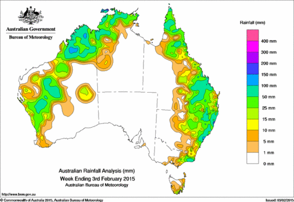
Rainfall recorded across Australia for the seven days to yesterday.
Totals between 50 mm and 100 mm were recorded across large parts of an area extending inland from the central west of Western Australia through to the Kimberley and the Top End of the Northern Territory, in the past week.
Weekly totals in parts of the Kimberley exceeded 100 mm.
Totals in excess of 50 mm were also recorded in parts of the east coast of Australia across the Cape York Peninsula and from central eastern Queensland to the central coastal district of New South Wales and in a small part of East Gippsland in Victoria.
Rainfall totals between 10mm and50 mm surrounded higher falls and were also recorded from the west coast to Gascoyne and Pilbara of Western Australia, in an area to the west of Uluru, and along most of the remainder of the east coast of mainland Australia reaching inland between central Queensland and central New South Wales, and also in coastal parts of southern and eastern Tasmania.
At the beginning of the week, a slow moving inland surface trough produced widespread moderate to heavy rainfall across southeast Queensland and across the tablelands of central New South Wales. The surface trough interacted with an onshore airstream resulting in further rainfall for northern and coastal New South Wales. Moist easterly winds also produced moderate rainfall for Queensland’s tropical coast. A developing low pressure system in the Tasman Sea produced rainfall across East Gippsland in Victoria and coastal southern and eastern Tasmania early in the week as it progressed southward, moving away from the mainland.
In the wake of the low pressure system, a strong ridge of high pressure directed an easterly airstream into New South Wales, bringing heavy falls on the northern New South Wales coast continuing to the end of the week.
Frequent thunderstorms and showers across the west and north of Western Australia during the week were associated with a trough of low pressure located along the west coast of Western Australia. The trough extended across the tropical north, producing showers and thunderstorms across the Top End of the Northern Territory and the Cape York Peninsula of Queensland.
Rainfall totals in excess of 200 mm were recorded in a pocket of coastal northern New South Wales, with the highest weekly total 247 mm at Coffs Harbour on the lower north coast.
Much of eastern and southern Western Australia, all of South Australia, central and southern Northern Territory, western Queensland, western New South Wales, western and central Victoria, and the remainder of Tasmania recorded little or no rainfall for the week.
Highest weekly totals in each state:
| State | Highest | 2nd Highest | 3rd Highest |
|---|---|---|---|
| WA | Fitzroy Crossing Aero (130 mm) (West Kimberley) |
Udialla (127 mm) (West Kimberley) |
Kachana (123 mm) (East Kimberley) |
| NT | Cape Don (151 mm) (Darwin-Daly) |
Pirlangimpi Airport (147 mm) (Darwin-Daly) |
Csiro Berrimah (126 mm) (Darwin-Daly) |
| SA | Parawa (Sharon) (5 mm) (East Central) |
Macclesfield (3 mm) (East Central) |
Parawa (3 mm) (East Central) |
| Qld | Upper Ulam Road (165 mm) (Port Curtis) |
Piccaninny Plains Station (162 mm) (North Peninsula) |
Tarana Crossing (126 mm) (Central Highlands) |
| NSW/ACT | Coffs Harbour (247 mm) (Lower North Coast) |
Coffs Harbour Airport (222 mm) (Lower North Coast) |
Woolgoolga (176 mm) (Lower North Coast) |
| Vic | Weeragua (109 mm) (East Gippsland) |
Club Terrace (103 mm) (East Gippsland) |
Cann River (97 mm) (East Gippsland) |
| Tas | Mount Wellington (69 mm) (Southeast) |
Friendly Beaches (44 mm) (East Coast) |
Nugent (37 mm) (East Coast) |
Source: BOM


HAVE YOUR SAY