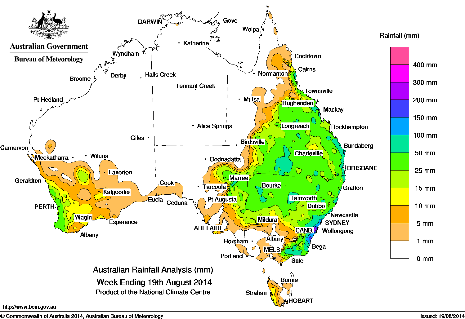
Rain fo the week ending 19 August, 2014. Click on map to view in large format
Rainfall was recorded in Queensland, New South Wales, eastern Victoria, parts of eastern South Australia, southwest Western Australia, and southwestern Tasmania.
At the beginning of the week, an upper-level low pressure system located near the border of South Australia and New South Wales led to a surface trough developing over western Queensland. By the 15th, a low pressure system had developed over northwest New South Wales and the end of the surface trough.
The systems deepened and moved east-southeast across Queensland with rain areas and isolated thunderstorms bringing moderate falls to southern Queensland, northwestern New South Wales and parts of eastern South Australia.
As the low pressure system reached the New South Wales coast in the second half of the week, the system became complex with multiple centres of low pressure emerging and localised heavy rain falling on the southern and central coast of New South Wales and far eastern Victoria.
During the week, a cold front first crossed southern parts of Western Australia before tracking through Tasmania with some light falls recorded in southwest Western Australia and western Tasmania. In the final days of the week a strong cold front and low pressure system approached southwest Western Australia with a westerly air stream persisting over southern parts of Western Australia, bringing moderate falls to the coastal southwest.
Rainfall totals over 300 mm were reported on the south coast of New South Wales. The highest weekly rainfall total of 324 mm was recorded at Robertson (Caalong Street) in New South Wales.
Rainfall totals between 100 mm and 200 mm were recorded in the coastal strip of southern New South Wales and isolated parts of the Victorian Alps.
Rainfall totals between 50 mm and 100 mm were recorded in parts of inland, coastal and southeastern New South Wales, southern and southeastern Queensland as well as isolated patches of the Queensland interior, central coast and north tropical coast, much of far eastern Victoria, and isolated areas of eastern South Australia.
Rainfall totals between 15 mm and 50 mm were recorded in several places including: southwest Western Australia and an isolated patch of the Southeast District in Western Australia; eastern South Australia; most of the remainder of New South Wales, except the southern inland area; Gippsland and northeast Victoria; parts of west coast Tasmania; and southern half of Queensland from about Cairns on the north tropical coast to Thargomindah in the southwest.
Rainfall totals over 10 mm were recorded in areas surrounding higher falls in southwest Western Australia, eastern South Australia, southern New South Wales, west coast Tasmania and the southern half of Queensland.
The Northern Territory and remaining parts of Western Australia, South Australia, Victoria and Queensland, and the eastern half of Tasmania recorded little or no rainfall for the week.
Highest weekly rainfall totals by state:
| State | Highest | 2nd Highest | 3rd Highest |
|---|---|---|---|
| WA | Mundaring (66 mm) (Central Coast) |
Balingup (64 mm) (South Coast) |
Bickley (55 mm) (Central Coast) |
| NT | No rainfall recorded | ||
| SA | Arkaroola (61 mm) (Far North) |
Wilpena Pound (43 mm) (Upper North) |
Boolcoomatta (35 mm) (Northeast) |
| Qld | Rocky Point Sugar Mill (118 mm) (Moreton) |
Rainbow Beach (115 mm) (Moreton) |
Toolara (109 mm) (Moreton) |
| NSW/ACT | Robertson (Caalong Street) (324 mm) (Illawarra) |
Beaumont (The Cedars) (322 mm) (Illawarra) |
Robertson (The Pie Shop) (322 mm) (Illawarra) |
| Vic | Mount Wellington (147 mm) (West Gippsland) |
Bullumwaal (147 mm) (East Gippsland) |
Buchan (Snowy River) (111 mm) (East Gippsland) |
| Tas | Mount Read (34 mm) (West Coast) |
Maatsuyker Island (16 mm) (Southeast) |
Low Rocky Point (14 mm) (West Coast) |
Source: BOM