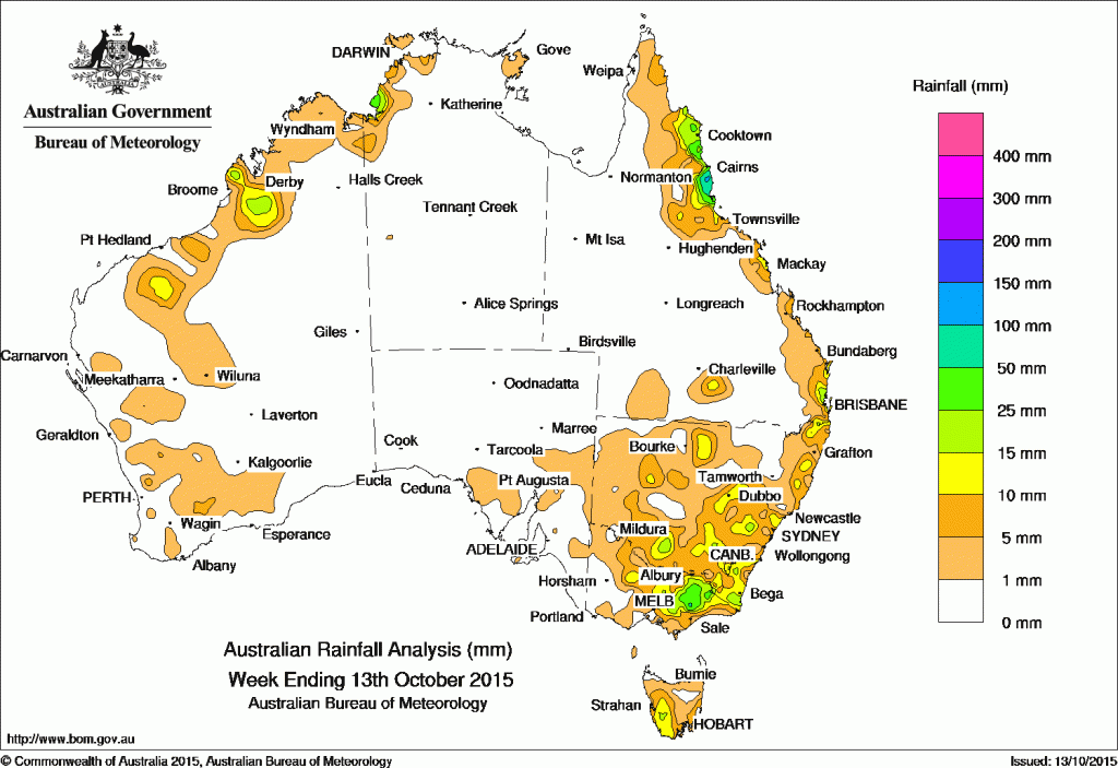
 Rainfall totals in excess of 50mm were recorded in parts of the north tropical Queensland coast, with some locations receiving more than 100 mm, including the highest weekly total of 108 mm at Tully Sugar Mill in Queensland.
Totals between 25 mm and 50 mm were recorded in an area surrounding higher falls from about Cape Flattery to Innisfail in north Queensland, in a small area of the western Darwin–Daly district in the Northern Territory, and in northeastern Victoria.
Less falls in the 10mm and 25mm range were recorded in southwest Tasmania, across much of northeastern to central Victoria, scattered areas of New South Wales, particularly in the southeast. Similar totals were received in the coastal pockets of Queensland’s southeast and the north tropical coast, a small part of the western Darwin–Daly district and in isolated spots in the Kimberley and eastern South West Land Division in Western Australia.
Most of Western Australia, the Northern Territory, South Australia, western Victoria, western and northern New South Wales, and all of Queensland away from the southeast and north tropical coasts recorded little or no rainfall in the past week.
At the beginning of the week, a trough and cold front crossed Tasmania, and in its wake, moderate rainfall totals were reported in the southwest of the State.
A strengthening and stagnant ridge along the east coast directed a moist onshore southeasterly airflow onto the Queensland east coast during the week, with moderate falls accumulating in the north tropical coast and areas of the eastern Cape York Peninsula. Areas of low pressure also lingered over the Kimberley and Top End, generating showers and thunderstorms and producing light falls about the Kimberley coast and areas of the northwest Top End throughout the week.
In the middle of the week, a broad surface trough stretched from central Australia, through western New South Wales and Victoria, producing showers and thunderstorm activity over much of southeastern Australia. Light to moderate falls were recorded across much of the eastern half of Victoria and throughout much of central and southern New South Wales, with some very light falls also over Tasmania.
New South Wales and Australian Capital Territory
51 mm Comboyne (Public School)
41 mm Newton Boyd (Abbey Green)
38 mm Yarras (Mount Seaview)
Victoria
65 mm Wonnangatta River
62 mm Falls Creek
56 mm Falls Creek (Rocky Valley)
Queensland
108 mm Tully Sugar Mill
98 mm South Johnstone
92 mm Innisfail
Western Australia
22 mm Country Downs
16 mm Bolgart Bin
15 mm Dampier Downs Airstrip
15 mm Dampier Downs
South Australia
4 mm Crystal Brook
3 mm Wilpena (Oraparinna)
3 mm Greenock
Tasmania
17 mm Warra
17 mm Tim Shea (Summit)
15 mm Fern Tree (Grays Road)
Northern Territory
36 mm Port Keats Airport
16 mm Charles Point
15 mm Dum In Mirrie Airstrip
More weekly rainfall totals:
NSW/ACT totals click here
Vic totals click here
Qld totals click here
WA totals click here
SA totals click here
Tas totals click here
NT totals click here
Source: BOM


HAVE YOUR SAY