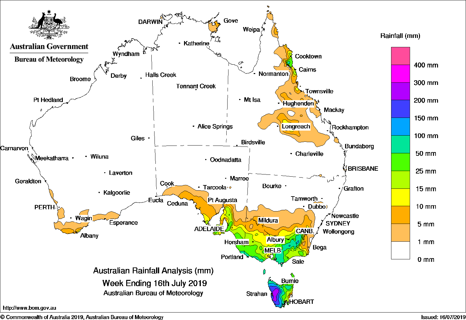
Several strong cold fronts generated moderate to heavy falls in southeast Australia, and snow in Alpine regions.
Showers produced moderate falls along the north tropical coast and in central Queensland.
Past seven days: At the start of the week, a cloudband associated with a strong cold front tracked over southeast Australia, with shower and thunderstorm activity generating moderate falls in parts of the southeast, with heavier falls in northern Tasmania. An easterly onshore flow combined with a surface trough extending from the Gulf Country to southeast Queensland, and produced showers and light to moderate falls across the Central Highlands District in Queensland. Onshore showers also produced moderate falls about the north tropical Queensland coast, and light falls about parts of the far northeast Top End in the Northern Territory.
Another cold front tracked across the southeast, and a vigorous westerly airstream became established over Tasmania, Victoria and southern New South Wales by mid-week. Strong winds and moderate to locally heavy falls were recorded in western Tasmania, from southern to northeastern Victoria, and in the elevated areas of the Snowy Mountains in New South Wales, with snow reported in Alpine regions. Widespread light falls were recorded across parts of the South Coast of Western Australia, southern South Australia, Victoria, western Tasmania and southern New South Wales.
At the end of the week, the next cold front tracked northeastwards across Tasmania, Victoria and far southeastern New South Wales. Further moderate falls were recorded in western Tasmania, southern central to northeastern Victoria, and in elevated areas of the Snowy Mountains in New South Wales.
Rainfall totals in excess of 150 mm were recorded in western Tasmania, including the highest weekly total of 238 mm at Queenstown.
Rainfall totals in excess of 100 mm were recorded in western Tasmania, and in small areas of the Victorian Alps and the Snowy Mountains in New South Wales.
Rainfall totals in excess of 50 mm were recorded across much of northern and western Tasmania; far southeastern South Australia; far southern Victoria extending into the State’s northeast, and across the border into the Snowy Mountains in New South Wales.
Rainfall totals between 10 mm and 50 mm were recorded in southern South Australia, most of Victoria except the far northwest, Tasmania, inland southeastern New South Wales, and along the north tropical coast, and in central Queensland.
Little or no rainfall was recorded in Western Australia, the Northern Territory, South Australia away from the coast, remaining parts of New South Wales away from the southeast, and most of Queensland apart from the north tropical coast and in the Central Highlands District.
Highest weekly totals
New South Wales and Australian Capital Territory
158 mm Perisher Valley AWS
124 mm Thredbo Village
93 mm Cabramurra AWS
Victoria
213 mm Falls Creek (Rocky Valley)
121 mm Mount Buller
119 mm Mount Baw Baw
Queensland
37 mm Mt Sophia, Whyanbeel Valley
34 mm Daintree Village
Western Australia
14 mm Cheyne Beach
11 mm Manypeaks
8 mm Hopetoun North, Barrett Meadows
South Australia
66 mm Ashton
58 mm Piccadilly (Woodhouse)
55 mm Lenswood
Tasmania
238 mm Queenstown (South Queenstown)
223 mm Zeehan
216 mm Lake St Clair National Park
Northern Territory
11 mm Alcan Minesite
10 mm Gove Airport
1 mm Ngayawili
Rainfall outlook:


HAVE YOUR SAY