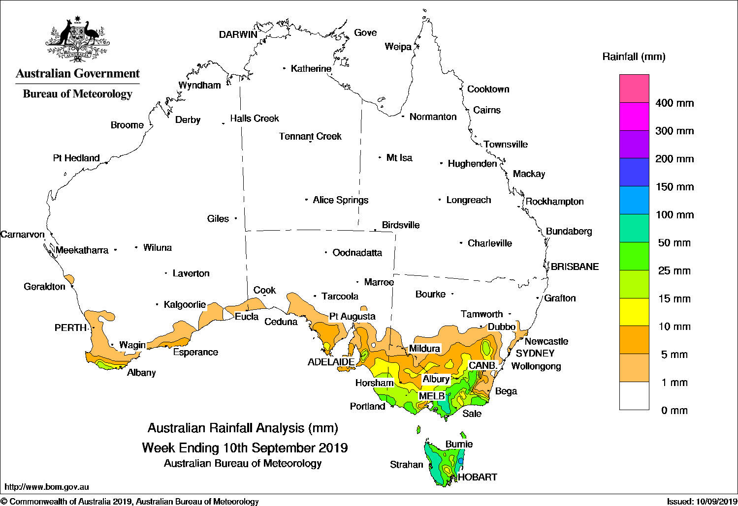
Past seven days: At the start of the week, a cold front tracked across Tasmania, and brought light falls to western parts of the state. In the west, another cold front approached south-west Western Australia and swept across the southern coast, generating light falls. As the system moved eastwards in the Bight, a pre-frontal trough produced light falls in south-eastern South Australia, southern Victoria and western Tasmania.
The cold front and associated low pressure system moved across the Great Australian Bight, with a complex area of low pressure developing over western Victoria, and an associated cold front stretching north into southern New South Wales. Light to moderate falls were reported in southern South Australia, southern Victoria and northern Tasmania.
By the middle of the week, the complex area of low pressure intensified over Tasmania, with multiple cold fronts extending north into Victoria and New South Wales. Moderate to heavy falls were recorded over most of Tasmania, with locally heavier falls in the state’s north-east. Moderate falls were also recorded from southern central to north-eastern Victoria, and in the Snowy Mountains in New South Wales, while widespread light falls were reported from south-eastern South Australia, remaining areas of Victoria and across the inland south-east of New South Wales.
At the end of the week, another cold front crossed the south-east, and produced widespread light falls in south-eastern South Australia, Victoria, Tasmania and in parts of inland southern New South Wales. Moderate falls associated with the passage of the cold front were recorded in southern central Victoria and western Tasmania.
Rainfall totals in excess of 100 mm were recorded in parts north-eastern and east coast Tasmania, including the highest weekly total of 181 mm at Gray (Dalmayne Rd), on the eastern coast.
Rainfall totals in excess of 50 mm were recorded in parts of Tasmania’s east and west coasts, and in areas of west and south Gippsland in Victoria.
Rainfall totals between 10 mm and 50 mm were observed along the far south coast of south-west Western Australia; south-eastern South Australia; most of Victoria except in the north-west; remaining areas of Tasmania; and in the Snowy Mountains and South West Slopes districts in New South Wales. Falls less than 10 mm were recorded along other parts of south-east Western Australia, southern South Australia, and areas of inland southern New South Wales.
Little or no rainfall was recorded in remaining areas of Western Australia, the Northern Territory, South Australia away from the south coast, Queensland, and New South Wales away from the inland south and the south-east.
Highest weekly totals
New South Wales and Australian Capital Territory
64 mm Perisher Valley AWS
51 mm Cabramurra AWS
42 mm Argalong (Sandy Creek)
Victoria
136 mm Mount Baw Baw
74 mm Warburton
68 mm Mount Buller
Queensland
0.4 mm Mornington Island Airport
0.2 mm Multiple locations
Western Australia
25 mm Northcliffe
19 mm Pemberton, Walpole Forestry
South Australia
38 mm Kersbrook, Cudlee Creek
37 mm Ashton
Tasmania
181 mm Gray (Dalmayne Rd)
113 mm Lewis Hill (St Pauls River)
102 mm St Helens Aerodrome
Northern Territory
0.2 mm Multiple locations
Rainfall outlook:
Source: BOM. (Technical problems at the source prevented the publication of our usual rainfall outlook maps this week)


HAVE YOUR SAY