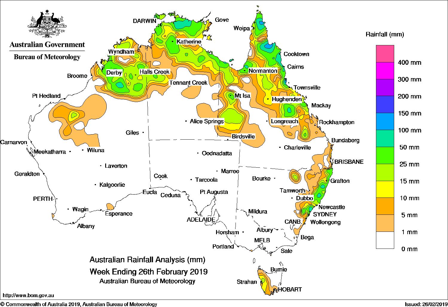
BROAD areas of low pressure across northern Australia produced thunderstorms and moderate fall, while onshore flow produced moderate falls along the east coast of Queensland and New South Wales.
Past seven days: At the start of the week, a broad area of low pressure extended across northern Australia, with thunderstorms and moderate falls in the Kimberley in Western Australia, the Top End in the Northern Territory, parts of the southern Cape York Peninsula and north tropical coast of Queensland. A cold front tracked across Tasmania, generating light falls in the west of the State. Tropical cyclone Oma was located well off the east coast of Queensland, and had little impact in terms of rainfall, but the system generated large waves and dangerous surf conditions along the south-east coast of Queensland.
From the middle of the week, a strengthening high pressure system moved into the Tasman Sea and extended a firm ridge along the east coast. A surface trough situated along the adjacent inland areas of the east coast of Queensland and New South Wales combined with a moist onshore flow, generating moderate falls along the east coast of New South Wales and parts of south-east Queensland.
In the last half the week, isolated thunderstorms developed along broad surface troughs, and produced moderate falls over parts of the Kimberley, the Top End of the Northern Territory, and Cape York Peninsula in Queensland. Onshore flow produced light to moderate falls along the north-east to central coasts of New South Wales. A surface trough extended from north-west to central Queensland and produced moderate falls across most of the Cape York Peninsula, with moderate to locally heavier falls recorded in parts of the north tropical to central coasts, and adjacent inland districts of Queensland. Thunderstorms also produced moderate falls in south-west Queensland as this trough drifted southwards.
Rainfall totals in excess of 100 mm were recorded in parts of the northeast of Cape York Peninsula and the north tropical Queensland coast, including the highest weekly total of 209 mm at Lucinda Township.
Rainfall totals exceeding 50 mm were recorded in parts of the Kimberley in Western Australia, the Top End in the Northern Territory, Cape York Peninsula, parts of the north tropical and central coasts of Queensland, and along areas of the east coast of New South Wales.
Rainfall totals between 10 mm and 50 mm were recorded across most of the Kimberley and parts of the eastern Pilbara in Western Australia; the Top End and Gulf Country in the Northern Territory; most of the Cape York Peninsula, the northern interior, north tropical coast, central coast and adjacent inland districts of Queensland. Similar totals were recorded in an area of south-west Queensland, from the north-east to central coasts of New South Wales, and western Tasmania.
Little of no rainfall was recorded in remaining parts of Western Australia; the southern two-thirds of the Northern Territory; South Australia; most of western and southern Queensland; all of New South Wales away from the east coast; Victoria and remaining parts of central to eastern Tasmania.
Highest weekly totals
New South Wales and Australian Capital Territory
100 mm Careys Peak (Barrington Tops)
94 mm Wyong (Olney Forest)
89 mm Dorrigo (Old Coramba Rd)Yamba Pilot Station
Victoria
1.8 mm Cape Otway Lighthouse, Jindivick
1.6 mm Mount Baw Baw, Wilsons Promontory Lighthouse
Queensland
209 mm Lucinda Township
172 mm Halifax Macrossan St
167 mm Victoria Sugar Mill
Western Australia
56 mm Napier Downs
54 mm Leopold Downs
50 mm Beefwood Park
South Australia
2 mm Brownhill Creek (Scotch College), Prospect Hill
1.4 mm Nairne
Tasmania
52 mm Mount Read
44 mm Lake Margaret Dam
24 mm Lake Margaret Power Station
Northern Territory
67 mm Jabiru Airport
64 mm Tindal Raaf
62 mm Darwin Airport, Upper Seventeen Mile Creek
More weekly rainfall totals:
- NSW/ACT totals click here
- Vic totals click here
- Qld totals click here
- WA totals click here
- SA totals click here
- Tas totals click here
- NT totals click here
Rainfall outlook:


HAVE YOUR SAY