For today’s 14-day rainfall outlook – scroll to bottom of article
A vigorous cold front and surface trough produced moderate falls in southeastern Australia. Moist, onshore airflow resulted in showers with moderate falls in southeastern Queensland.
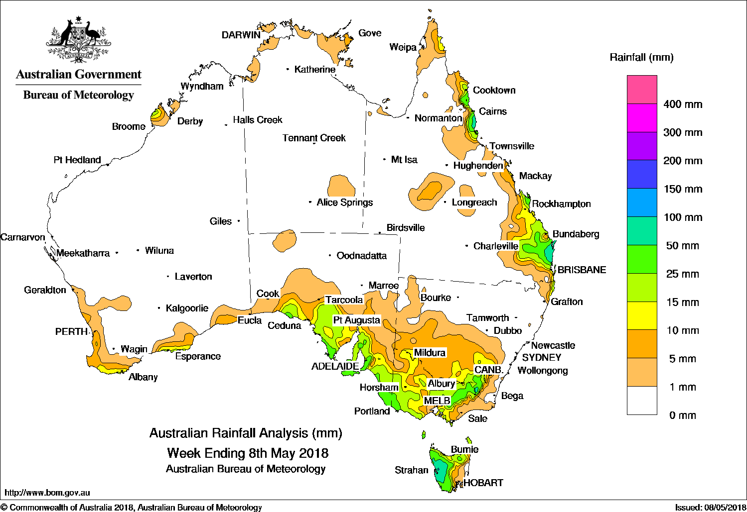
Past seven days: At the beginning of the week, a moist onshore flow brought showers and moderate rainfall totals to the north tropical Queensland coast, and light falls along much of the rest of Queensland’s east coast. In the south, a cold front, pre-frontal trough, and an associated middle level cloudband tracked across southern Australia, and produced moderate falls along the southern coast of Western Australia and South Australia. A second cold front and low pressure system followed closely, and tracked across southeastern Australia. The vigorous westerly flow produced moderate falls from southeastern South Australia, across southwestern Victoria and along the inland slopes of the Great Dividing Range from central Victoria to the Snowy Mountains in New South Wales. Moderate falls were also recorded in northern and western Tasmania.
During the middle of the week, a strong and gusty west to northwesterly flow ahead of a cold front produced moderate falls over western Tasmania. Light showers continued along parts of the east coast of Queensland due to a persistent moist onshore flow, while onshore flow brought showers to the West Kimberley and Northern Territory coasts. At the end of the week, a surface and upper level trough produced widespread showers and moderate falls in southeastern Queensland and in adjacent inland districts.
Rainfall totals in excess of 50 mm were recorded about the southeast and north tropical coasts of Queensland, and along the central west coast of Tasmania. Isolated spots along the west coast of Tasmania recorded rainfall totals in excess of 100 mm, including the highest weekly total of 159 mm at Mount Read.
Rainfall totals between 25 mm and 50 mm were recorded along the west-facing coasts of South Australia, in far southwestern Victoria and along the inland slopes of the Great Dividing Range extending across the border into the Snowy Mountains district of New South Wales, about the north tropical coast and southeast Queensland.
Rainfall totals between 10 mm and 25 mm were recorded around Broome on the West Kimberley coast; along the south coast of Western Australia; agricultural and southeastern districts of South Australia; across western, central and northeastern Victoria; northern and central Tasmania; inland southeastern New South Wales, and around heavier falls in eastern Queensland.
Little or no rainfall was recorded in the Northern Territory, Western Australia away from the south coast, Queensland away from the east coast, central and northern South Australia, northern and eastern New South Wales, most of Gippsland in Victoria, and eastern Tasmania.
Highest weekly totals
New South Wales and Australian Capital Territory
85 mm Thredbo Village
73 mm Thredbo AWS
57 mm Perisher Valley AWS
Victoria
62 mm Falls Creek (Rocky Valley)
53 mm Mount Buller
50 mm Mt Sunday
Queensland
100 mm Bingil Bay
96 mm Sunshine Coast Airport
93 mm Tin Can Bay (Defence)
Western Australia
21 mm The Duke
19 mm Dalyup Park, Denmark
South Australia
58 mm Uraidla
57 mm Lenswood
56 mm Myponga
Tasmania
159 mm Mount Read
99 mm Queenstown (South Queenstown)
94 mm Lake Margaret Power Station
Northern Territory
18 mm McCluer Island
17 mm Humpty Doo Collard Road
10 mm Noonamah Airstrip
More weekly rainfall totals:
- NSW/ACT totals click here
- Vic totals click here
- Qld totals click here
- WA totals click here
- SA totals click here
- Tas totals click here
- NT totals click here
Source: BOM


HAVE YOUR SAY