For today’s 14-day rainfall outlook – scroll to bottom of article
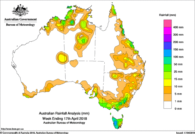
Several cold fronts tracked across southeastern Australia, generating moderate falls, while broad low pressure troughs generated showers and storms in the coastal northern tropics.
Past seven days: During the first half of the week broad areas of low pressure extending across northern and central Australia generated thunderstorms and showers with moderate falls recorded about the Kimberley, central interior of Western Australia, Cape York Peninsula, Top End, and central parts of the Northern Territory. A moist, onshore flow produced showers along Queensland’s central coast.
Early in the week, a cold front and surface trough tracked across southeastern Australia and produced light falls in Tasmania, southwestern Victoria and southeastern South Australia. A surface trough located over southwest Western Australia triggered shower activity with light falls recorded across the State’s southern coast.
A low pressure system and upper level trough tracking over Tasmania generated thick middle level cloud and thunderstorms, and produced moderate falls in western Tasmania.
During the middle of the week, a pair of vigorous cold fronts tracked across southeastern Australia, and produced a cloudband with embedded thunderstorms and strong to gale force westerly winds. Moderate falls were recorded in southeastern South Australia, southern and northeastern Victoria, western and northern Tasmania, and elevated parts of the Snowy Mountains in New South Wales. A surface trough extending towards the fronts was located through inland Queensland and New South Wales, and triggered showers and thunderstorms; light to moderate falls were reported in northern and eastern parts of New South Wales; also across the southern and central interior, and east coast of Queensland. The passage of further troughs and cold fronts during the remainder of the week generated continuing moderate falls in western Tasmania, with light falls about southern and northeastern Victoria.
At the end of the week, a surface trough near the north Queensland coast produced showers with moderate to locally heavy falls recorded about the northern Cape York Peninsula and north tropical coast of Queensland.
Rainfall totals in excess of 100 mm were recorded in western Tasmania, and elevated areas of the Victorian Alps. The highest weekly total was 138 mm at Lake Margaret in western Tasmania.
Rainfall totals in excess of 50 mm were recorded at several locations in both the Darwin-Daly District in the Northern Territory and the Kimberley in Western Australia, a pocket of the north tropical Queensland coast, about the Mount Lofty Ranges in South Australia, at locations on the southern coast and in northeastern Victoria, and across the western half of Tasmania.
Rainfall totals between 10 mm to 50 mm were observed in parts of the northern Kimberley, and about the Top End, Gulf Country and central parts of the Northern Territory; along parts of Queensland’s east coast and southern interior.
Totals between 10 mm and 50 mm were recorded in southeastern Australia covering central southern and southeastern South Australia; southwestern, central and northeastern Victoria; about the ranges in southeastern New South Wales, and across most of Tasmania. Falls exceeded 25 mm in most of southwest Victoria and along the Great Dividing Range, and surrounding heavier falls in western and northern.
Small weekly totals, generally up to 10 mm, were recorded along the southern coast of Western Australia, to the west of Uluru, and across much of eastern New South Wales.
Little or no rainfall was recorded in Western Australia away from the Kimberley, central interior and south coast; most of South Australia except for agricultural regions; northwestern Victoria; most of western New South Wales and some areas along the coast; western and southern Queensland; and the Northern Territory away from the Top End, Gulf Country and central interior.
Highest weekly totals
New South Wales and Australian Capital Territory
114 mm Perisher Valley AWS
83 mm Thredbo Village
60 mm Cabramurra AWS
Victoria
153 mm Mount Buller
126 mm Falls Creek (Rocky Valley)
83 mm Howitt Plains (High Ridge)
Queensland
160 mm Tully Sugar Mill
95 mm Innisfail Aerodrome
87 mm Cowley Beach (Defence)
Western Australia
39 mm Kalumburu
31 mm Kununurra Aero
25 mm Windy Harbour
South Australia
90 mm Crafers West
76 mm Ashton Co-Op
75 mm Lenswood
Tasmania
138 mm Lake Margaret Power Station
122 mm Queenstown (South Queenstown)
110 mm Zeehan
Northern Territory
84 mm Pirlangimpi Airport
67 mm Marrara
62 mm Darwin Hospital
More weekly rainfall totals:
- NSW/ACT totals click here
- Vic totals click here
- Qld totals click here
- WA totals click here
- SA totals click here
- Tas totals click here
- NT totals click here
Source: BOM
14 Day rainfall outlook:


HAVE YOUR SAY