For today’s 14-day rainfall outlook – scroll to bottom of article
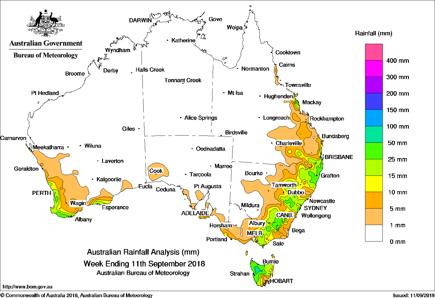
Onshore flow brought moderate falls to the east coast between central Queensland and northeastern New South Wales at the start of the week, while a low and a cold front produced moderate falls over southeastern Australia mid-week.
Past seven days: At the start of the week, a surface trough and weak low pressure system extended through eastern Queensland to northern New South Wales, and combined with an onshore flow to produce showers and moderate falls on Queensland’s central coast and in southeastern Queensland and northeastern New South Wales. In the west, a cold front tracked across southwest Western Australia, with widespread light falls reported in the South West Land Division; higher totals were recorded in a small area of the southwest coast.
By the middle of the week, a trough moved from central Australia into the eastern States and a low pressure system developed over northern inland New South Wales. As the cold front tracked across the southeast moderate totals fell in parts of eastern New South Wales, central and northeastern Victoria, and northern and western Tasmania. The system stalled over northeastern New South Wales before moving slowly offshore, with showers and thunderstorms continuing over the southern interior of Queensland, and northern and central New South Wales, with widespread light falls lingering over southeastern Queensland.
In the last part of the week, a cold front and trough embedded in a strong westerly flow generated moderate falls in northwestern Tasmania. Another cold front approached and tracked across southwest Western Australia, with light falls recorded about the southwest of the State.
Rainfall totals exceeding 50 mm were recorded in parts of western and northern Tasmania, and an area of northeastern New South Wales. The highest weekly total was 133 mm at Ballina in northeastern New South Wales.
Rainfall totals between 10 mm and 50 mm were recorded along the southwest and southern coasts of Western Australia, far southeastern South Australia, central and northeastern Victoria and South and West Gippsland, most of Tasmania, large parts of eastern New South Wales, and in southeastern and central Queensland.
Little or no rainfall was observed in remaining parts of Western Australia, the Northern Territory, most of South Australia, northwest Victoria, western New South Wales, and most of Queensland away from the southeast quarter.
Highest weekly totals
New South Wales and Australian Capital Territory
133 mm Ballina Airport AWS
74 mm Bankstown Airport AWS
68 mm Harwood Island
Victoria
46 mm Mount Hotham
40 mm Falls Creek (Rocky Valley)
37 mm Corryong Airport
Queensland
55 mm Ooralea Racecourse
48 mm Farleigh Co-Op Sugar Mill
46 mm Ormiston College
Western Australia
49 mm Walpole Forestry
39 mm Dwellingup
38 mm Pemberton
South Australia
15 mm Flinders Chase (Rocky River)
12 mm Mount Schank (Jethia)
10 mm Mount Gambier AeroLake George
Tasmania
72 mm Mount Read
54 mm Erriba (Jubb Road)
49 mm Yolla (Sea View)
Northern Territory
0.2 mm Upper Seventeen Mile Creek, Upper Fergusson River, Mount Stow
More weekly rainfall totals:
- NSW/ACT totals click here
- Vic totals click here
- Qld totals click here
- WA totals click here
- SA totals click here
- Tas totals click here
- NT totals click here
Rainfall outlook:


HAVE YOUR SAY