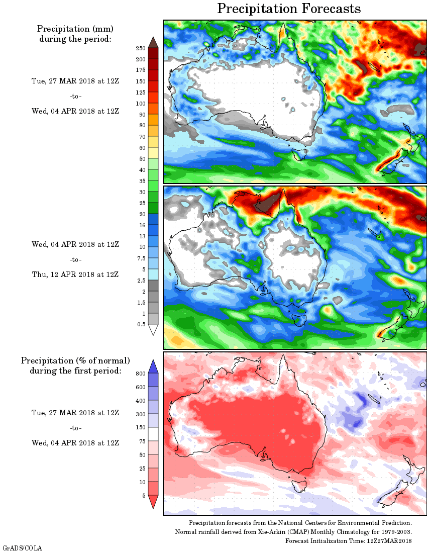
For today’s 14-day rainfall outlook – scroll to bottom of article
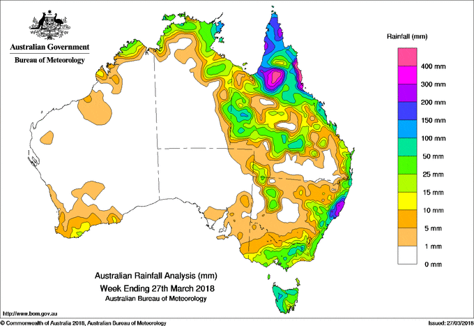
Severe tropical cyclone Nora and the associated monsoon trough brought heavy falls across Far North Queensland. A coastal trough and onshore flow produced heavy rainfall in the central and mid north coast of New South Wales.
Past seven days: Throughout the week, a tropical low, which had persisted in the Arafura Sea, developed to tropical cyclone Nora north of Cape Wessel in the Northern Territory. TC Nora then tracked southeast towards the Gulf Carpentaria and crossed the Cape York Peninsula in Queensland as a severe cyclone (category 3) and continued to travel south along the Gulf Country coast before moving inland and weakening to a tropical low. Severe TC Nora or its remnant, and associated monsoon trough, produced moderate to heavy rainfall to the northern Top End and eastern parts of Northern territory, across the northern, western, central and east coast of Queensland, with very heavy falls and flooding recorded in the Cape York Peninsula coasts and Gulf Country.
In the first part of the week, a trough near the east coast, combined with a slow-moving strong high pressure system southeast of Tasmania, produced moderate to heavy falls to the central and north coast of New South Wales and southeast Queensland coast, with very heavy rainfall and thunderstorms recorded between Newcastle and Coffs Harbour. Troughs in the inland eastern Australia produced some moderate rainfall to the southwest, and central Queensland, northwest New South Wales, and northeastern South Australia.
From mid-week, troughs and cold fronts embedded in vigorous west to north-westerly winds, which connected to a complex low pressure system south of Tasmania, tracked across the southeast of Australia. Mean-while, a cloudband associated with ex-TC Marcus off the west coast of Western Australia, extended to southern mainland and Tasmania. Moderate rainfall was recorded in along the south coast and eastern Victoria, the southeast and central tableland in New South Wales, and in Tasmania. The remnant of ex-TC Marcus brought mostly light rainfall with isolated moderate falls in the southwest of Western Australia.
The monsoon trough brought moderate falls in the northern Kimberley in Western Australia early in the week
Rainfall totals in excess of 400 mm were recorded along the north tropical coast in Queensland and the Mid North Coast district in New South Wales. The highest weekly total was 776 mm at Port Douglas in the north tropical coast in Queensland.
Rainfall totals between 150 mm and 400 mm were recorded in the north and west of Cape York Peninsula, and northeast of Gulf Country in Queensland, the east coast of New South Wales between Newcastle and Coffs Harbour.
Rainfall totals between 50 mm to 150 mm were recorded in the northeastern Top End in Northern Territory, most of the Cape York Peninsula, and areas in the east coast in Queensland, much of the central and north coast, and inland southeast in New South Wales, inland Gippsland in Victoria, in western and northern Tasmania.
Rainfall totals between 10 mm to 50 mm were recorded in the far north and south coast of Western Australia, the northern Top End and eastern Northern Territory, most of the Queensland away from the southern inland, along the east coast, northwest, central tableland and inland southeast in New South Wales, and Tasmania.
Little or no rainfall was recorded across Western Australia away from the northern Kimberley and south coast, the Northern Territory away from the northern Top End and eastern areas, southern inland Queensland, most of inland New South Wales, the northwest Victoria, and in South Australia except the far northeast and southeast.
Highest weekly totals
New South Wales and Australian Capital Territory
446 mm Yarras (Mount Seaview)
438 mm Forster – Tuncurry Marine Resc
389 mm Mooral Creek (The Den)
Victoria
94 mm Mount Hotham
70 mm Falls Creek (Rocky Valley)
61 mm Mt Sunday
Queensland
776 mm Port Douglas – Warner St
694 mm Tully Sugar Mill
682 mm Kuranda Railway Station
Western Australia
58 mm Kalumburu
46 mm Truscott
43 mm Theda
South Australia
62 mm Moomba Airport
18 mm Eudunda, Coomandook
Tasmania
177 mm Mount Read
99 mm Queenstown (South Queenstown)
92 mm Savage River Mine
Northern Territory
146 mm Csiro Berrimah
137 mm Gove Airport
132 mm Yirrkala Tropical Gardens
More weekly rainfall totals:
- NSW/ACT totals click here
- Vic totals click here
- Qld totals click here
- WA totals click here
- SA totals click here
- Tas totals click here
- NT totals click here
Source: BOM


HAVE YOUR SAY