EARLY in the week, a low pressure trough extending from western Western Australia towards eastern parts of the continent, dragged tropical air from the warm ocean waters, delivering thunderstorms and rainfall to large parts of eastern and south-eastern Australia.
Another low pressure system offshore from the Pilbara streamed moisture into Western Australia producing showers, thunderstorms and rain.
 Multiple fronts and low pressure troughs crossed southern parts of the country bringing cool and showery weather to south-eastern Australia on most days.
A low pressure trough combined with a moist on-shore easterly flow producing showers and thunderstorms in parts of the central Queensland and New South Wales coasts at the end of the week.
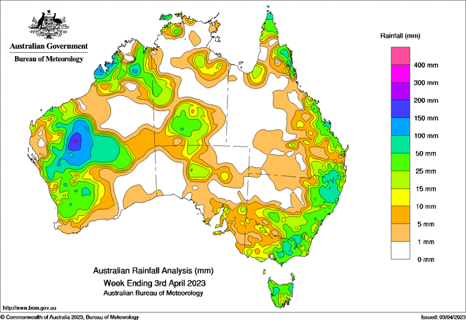
Weekly totals greater than 50 mm were recorded across the Gascoyne and into Southern Interior districts in Western Australia; a large area within the Gascoyne district received more than 100 mm. Weekly totals above 50 mm were also recorded in coastal parts of the Kimberley in Western Australia, in Tasmania, along the ranges in Victoria and New South Wales, and in areas of coastal Queensland.
The highest weekly total (at a bureau gauge) of 209.6 mm was recorded at Doolguna, WA; the highest daily total this week was 115.5 mm at Jervis Bay, NSW, in the 24 hours to 9am on 1 April.
Weekly totals between 10 and 50 mm were recorded in parts of south-western Western Australia, most of Tasmania, southern and eastern Victoria, much of eastern New South Wales and in coastal parts of Queensland and most of Cape York Peninsula.


HAVE YOUR SAY