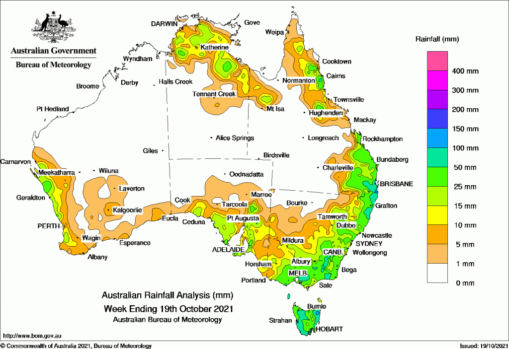
RAIN was widespread across the continent over the past week, with heavy falls particularly in the east and south-east.
A surface trough early in the week brought thunderstorms and moderate falls to southern South Australia, Victoria, northern Tasmania, eastern New South Wales and south-east Queensland.
Later in the week a surface and upper-level trough produced thunderstorms, and some giant hail, from the Capricornia coast to north east New South Wales, and adjacent inland districts.
A cold front brought moderate falls to the west coast of Western Australia. Isolated thunderstorms developed in the Top End.
Past seven days: For the week to 19 October 2021, rainfall was recorded along the west coast of Western Australia, in the north of the Northern Territory, eastern Queensland, and across south-eastern Australia including Tasmania.
At the start of the week, a surface trough extended from north-west to south-east Queensland, and combined with moist onshore flow to produce thunderstorms and moderate falls across south-east Queensland and the north-eastern quarter of New South Wales. A cold front was located over eastern South Australia, with an associated low pressure system in the Great Australian Bight. The system moved eastwards into central New South Wales and Victoria, and generated a cloud band with isolated thunderstorms. Moderate falls were recorded in southern South Australia, Victoria, northern Tasmania, eastern New South Wales and south-east Queensland. Thunderstorms developed in the Top End of the Northern Territory and parts of the gulf country, along a surface trough across northern Australia.
The low pressure system moved over eastern South Australia, with an associated pair of cold fronts located over western and eastern New South Wales. Secondary lows were also in the western and eastern Bass Strait. The complex low pressure system brought severe storms, damaging to destructive winds, and widespread rain with moderate to locally heavy falls across the east and south-east, including Tasmania. A tornado was confirmed at Armidale in New South Wales on the 14th. A surface trough also extended from south-east to north-west Queensland and across the Top End, with showers and thunderstorms generating moderate falls in north-east and south-east Queensland and the north-east Top End.
Isolated showers brought light falls to parts of the north and south of the country in the middle of the week.
At the end of the week, a surface and upper-level trough produced thunderstorms from the Capricornia to south-east coasts, and adjacent inland districts, and in north-east New South Wales, with giant hail and heavy rainfall associated with the storms. A weak cold front crossed Tasmania and a pre-frontal trough tracked through Victoria, generating moderate falls in north-east Tasmania and East Gippsland in Victoria. In the west, a cold front brought moderate falls along the west coast between Shark Bay and Bunbury in Western Australia. Isolated thunderstorms developed in the Top End.
Rainfall totals in excess of 100 mm were recorded in small areas of south-east Queensland, north-east New South Wales, and north-east Tasmania. The highest weekly total was 241 mm at Gray (Dalmayne Road) in Tasmania.
Rainfall totals in excess of 50 mm were recorded northern and southern Tasmania, parts of southern and eastern Victoria, south-east and north-east New South Wales, and south-east Queensland.
Rainfall totals between 10 mm and 50 mm were recorded along the west coast of Western Australia, southern South Australia, most of Victoria except the north-west corner, Tasmania, the south and eastern half of New South Wales, parts of eastern Queensland, and in the north of the Northern Territory.
Highest weekly totals list and map
New South Wales and Australian Capital Territory
128 mm Bellwood (Nambucca Heads)
122 mm Tweed Heads Golf Club
111 mm Evans Head RAAF
Victoria
92 mm Ferny Creek
91 mm Kinglake West
85 mm Mount Baw Baw
Queensland
130 mm Springbrook Road
125 mm Clontarf
124 mm Manly Railway Station
Western Australia
32 mm Lancelin (Defence)
27 mm Jurien Bay
26 mm North Island, Kalbarri
South Australia
72 mm Wirrabara Forest
47 mm Crafers West
46 mm Felixstow (Payneham)
Tasmania
241 mm Gray (Dalmayne Rd)
190 mm Pyengana (Forest Lodge Road)
126 mm Mount Barrow (South Barrow)
Northern Territory
56 mm Labelle Downs
32 mm Fanny Creek
31 mm Upper Seventeen Mile Creek
![]()


HAVE YOUR SAY